Weather history miscellany
Re: Weather history miscellany
https://www.weatherforyou.com/weather_history/12-11
1932 - Very cold weather prevailed along the West Coast. San Francisco received 0.8 inch of snow, and at the airport the temperature dipped to 20 degrees. At Sacramento CA, the mercury dipped to 17 degrees to establish an all-time record low for that location. Morning lows were below freezing from the 9th to the 15th at Sacramento, and the high on the 11th was just 34 degrees. The cold wave dealt severe damage to truck crops and orange groves in the Sacramento Valley. (David Ludlum) (The Weather Channel)
1988 - Arctic cold invaded the central and eastern U.S. Sault Ste Marie MI reported a record low of 14 degrees below zero, and International Falls MN was the cold spot in the nation with a low of 25 degrees below zero. Temperatures remained below zero all day over parts of eastern Upper Michigan and northern New England. (The National Weather Summary)
2008 - A rare snowstorm swept across parts of south Louisiana and Mississippi, blanketing the area with snow. Nearly 8 inches of snow fell over parts of Louisiana. These conditions caused schools and bridges to close and left thousands of residents without power (Associated Press). (NCDC)
2010 - The "Pineapple Express" - a meteorological event where southwest winds bring warm, moist air to the U.S. West Coast - produced record rainfall to the Pacific Northwest during December 11th-12th. Seattle experienced record daily rainfall two days in a row. The Seattle-Tacoma International Airport recorded 1.42 inches of rain on the 11th, breaking the old daily record of 1.32 inches set in 1955. The next day, 2.19 inches fell, breaking the daily record of 1.70 inches set in 1966. The Stillaguamish River in western Washington state reached 21.06 feet at Arlington, tying the record set in November 2006. Flood stage for the river is 14 feet. The storm system also brought record warmth to the area. On December 14th, the temperature at Seattle-Tacoma International Airport reached 57, breaking the old daily record of 55 set in 2004. (NCDC)
Re: Weather history miscellany
https://www.weatherforyou.com/weather_history/12-12
1882 - Portland, OR, was drenched with 7.66 inches of rain, a record 24 hour total for that location. (12th-13th) (The Weather Channel)
1960 - The first of three Middle Atlantic snowstorms produced a foot of snow at Baltimore MD. A pre-winter blizzard struck the northeastern U.S. producing wind gusts as high as 51 mph, along with 16 inches of snow at Nantucket MA, and 20 inches at Newark NJ. (David Ludlum)
1988 - Cold arctic air spread from the Great Lakes Region to the Appalachian Region. Twenty-five cities, mostly in the northeastern U.S., reported record low temperatures for the date. The low of 12 degrees below zero at Albany NY was their coldest reading of record for so early in the season. Saranac Lake NY was the cold spot in the nation with a low of 28 degrees below zero. (The National Weather Summary)
2008 - A significant ice storm wreaked havoc across New York and New England on December 12, disrupting electricity and leaving over 1 million homes and businesses without power. New Hampshire alone had as many as 320,000 residents without power, which according to reports it was described as the worst outages in 30 years (Reuters). Four fatalities were reported and parts of Massachusetts, New Hampshire, New York, and Maine declared a state of emergency (BBC News).
Re: Weather history miscellany
https://www.weatherforyou.com/weather_history/12-13
1962 - A severe Florida freeze occurred. Morning lows reached 35 degrees at Miami, 18 degrees at Tampa, and 12 degrees at Jacksonville. It was the coldest December weather of the 20th century and caused millions of dollars damage to crops and foliage. In Georgia, the morning low of 9 degrees below zero at Blairsville established a state record for the month of December. (David Ludlum) (The Weather Channel)
1988 - Low pressure off the Atlantic coast produced up to a foot of snow in eastern Nassau County and western Suffolk County of southeastern New York State. Mild weather prevailed across the western half of the country. Nine cities reported record high temperatures for the date, including Goodland KS with a reading of 74 degrees. (The National Weather Summary) (Storm Data)
2002 - A powerful Pacific storm system plowed into the western United States during the 13th-16th, producing high winds, heavy rains, significant mountain snowfall and causing 9 deaths (Associated Press). Rainfall amounts exceeding 10 inches occurred in parts of California, and wind gusts over 45 mph produced up to 1.9 million power outages during the period (Pacific Gas & Electric).
Re: Weather history miscellany
https://www.weather.gov/abr/This_Day_in ... ory_Dec_14
1952: Trace of snow or sleet at or near Pensacola, Crestview, DeFuniak Springs, Quincy, Carrabelle, Tallahassee, St. Marks, Monticello, Madison, Mayo, Live Oak, Lake City, Glen St. Mary, and Hilliard in Florida. Frozen precipitation occurred before noon at most points, but happened in the afternoon at Mayo and Lake City and near Hilliard. Temperatures were above freezing and snow or sleet melted as it fell.
1952: Trace of snow or sleet at or near Pensacola, Crestview, DeFuniak Springs, Quincy, Carrabelle, Tallahassee, St. Marks, Monticello, Madison, Mayo, Live Oak, Lake City, Glen St. Mary, and Hilliard in Florida. Frozen precipitation occurred before noon at most points, but happened in the afternoon at Mayo and Lake City and near Hilliard. Temperatures were above freezing and snow or sleet melted as it fell.
Re: Weather history miscellany
NASA Earth Observatory
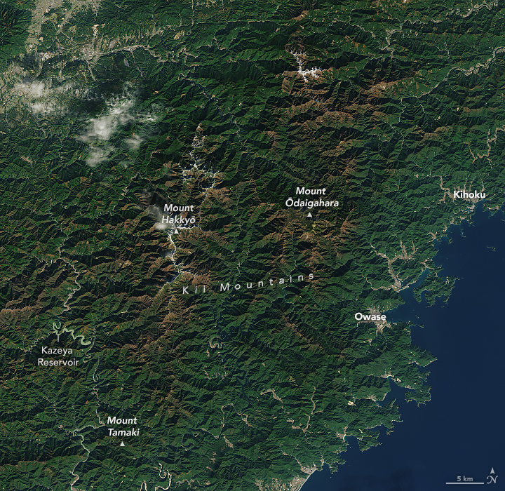
Hints of Color in Japan’s Kii Mountains(December 2, 2024)
"Seekers of autumn color in Japan had to wait a bit longer in 2024. The season for “Momijigari,” or “red leaf hunting,”
was forecast to arrive later than normal, potentially setting new records for its delayed appearance in some places."
https://www.geonames.org/1859499/kii-sammyaku.html
Momijigari
Re: Weather history miscellany
https://www.weather.gov/abr/This_Day_in ... ory_Dec_15
1992: Cyclone John hit the sparsely populated northwest coast of Australia with winds gusting to 185 mph. John was the strongest cyclone to hit Australia in over 100 years.
1992: Cyclone John hit the sparsely populated northwest coast of Australia with winds gusting to 185 mph. John was the strongest cyclone to hit Australia in over 100 years.
Re: Weather history miscellany
https://www.weatherforyou.com/weather_history/12-16
1988 - Fairbanks, AK, reported freezing rain and record warm temperatures. The afternoon high of 41 degrees was 43 degrees above normal. Snow and high winds continued to plague the mountains of southern California. Mount Wilson CA reported two inches of rain in six hours during the early morning, and a storm total of more than 3.50 inches of rain. (The National Weather Summary)
2000 - An F4 tornado hits communities near Tuscaloosa, AL, killing 11 people and injuring 125 others. It was the strongest December tornado in Alabama since 1950.
Re: Weather history miscellany
https://www.weather.gov/abr/This_Day_in ... ory_Dec_17
1924: From the Monthly Weather Review, "a severe glaze storm occurred in west-central Illinois on December 17 and 18, the area of great destruction embracing a territory about 75 miles in width and 170 miles in length. In the affected area, trees were badly damaged, wires broken, and thousands of electric poles went down. Electric services were paralyzed, and it required weeks to restore operation and months to permanently rebuild the lines.
The street railway company and the Illinois Traction System resumed complete operation 17 days after the storm. Electric light service was completely restored January 10. The ice had practically disappeared from the trees and wires by January 4, but on January 20, there was still considerable ice on the ground.
The Western Union Telegraph Co. lost 8,000 poles and the Illinois Bell Telephone Co. about 23,000. The total damage to wire service in Illinois probably equaled or exceeded $5,000,000." If the loss of business, the damage to trees and possible injury to winter grains, the storm may be considered one of the most disastrous of its kind in the history of Illinois."
Re: Weather history miscellany
https://www.weather.gov/abr/This_Day_in ... ory_Dec_18
1944: Typhoon Cobra, also known as the Typhoon of 1944 or Halsey's Typhoon (named after Admiral William "Bull" Halsey), was the United States Navy designation for a tropical cyclone that struck the Task Force 38 in the during World War II in the Pacific. The typhoon was first observed on December 17 as it surprised a fleet of ships in the open waters of the western Pacific Ocean. Sustained winds associated with the storm were up to 100 mph with gusts to 140 mph. On December 18, the small but violent typhoon hit the Task Force while many of the ships were attempting to refuel. Due to the extreme seas and winds, three destroyers capsized and went down with practically all hands, while a cruiser, five aircraft carriers, and three destroyers suffered serious damage. Approximately 790 officers and men were lost or killed with another 80 injured. This storm inflicted more damage on the Navy than any storm since the hurricane at Apia, Samoa, in 1889. In the aftermath of this deadly storm, the Pacific Fleet established new weather stations in the Caroline Islands and, as they were secured, Manila, Iwo Jima, and Okinawa. Also, new weather central offices (for coordinating data) were established at Guam and Leyte.
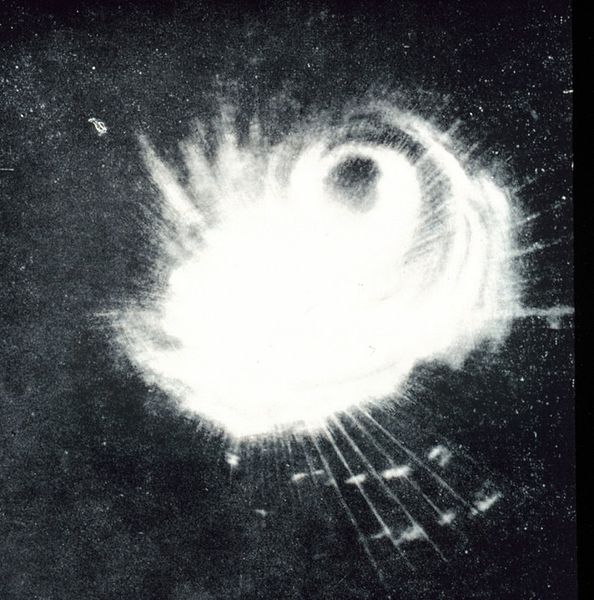
A Navy ship's radar captured the structure of a typhoon on December 18. This storm was
the second tropical storm ever to be observed on radar East of the Philippine Islands.
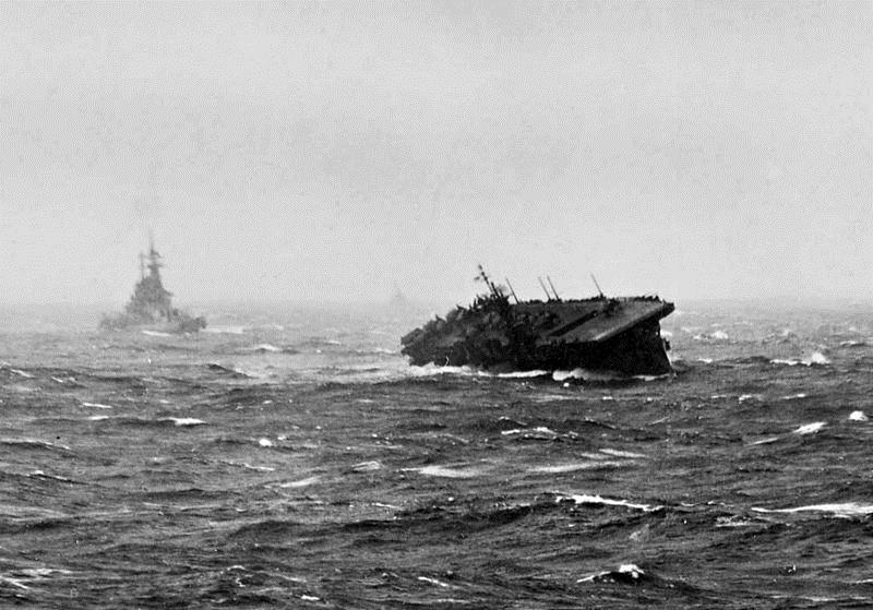
The U.S. Navy light aircraft carrier USS Langley (CVL-27) rolling heavily during Typhoon
Cobra, 18 December 1944. A battleship is steaming behind the carrier. U.S. Navy
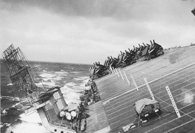
A view of USS Cowpens (CVL-25) starboard side flight deck facing aft from the island. The
photo was taken at the time Typhoon Cobra hit the Third Fleet on 18 December 1944.
1986: A strong winter storm, which developed off the coast of New Jersey and moved out to sea, lashed the northeastern U.S. with high winds, heavy rain, and heavy snow. The storm left snowfall amounts of up to 30 inches in Vermont, 24 inches in Massachusetts, and 20 inches in New Hampshire. The highest rainfall amounts approached four inches in southern New England, where winds gusted to 70 mph.
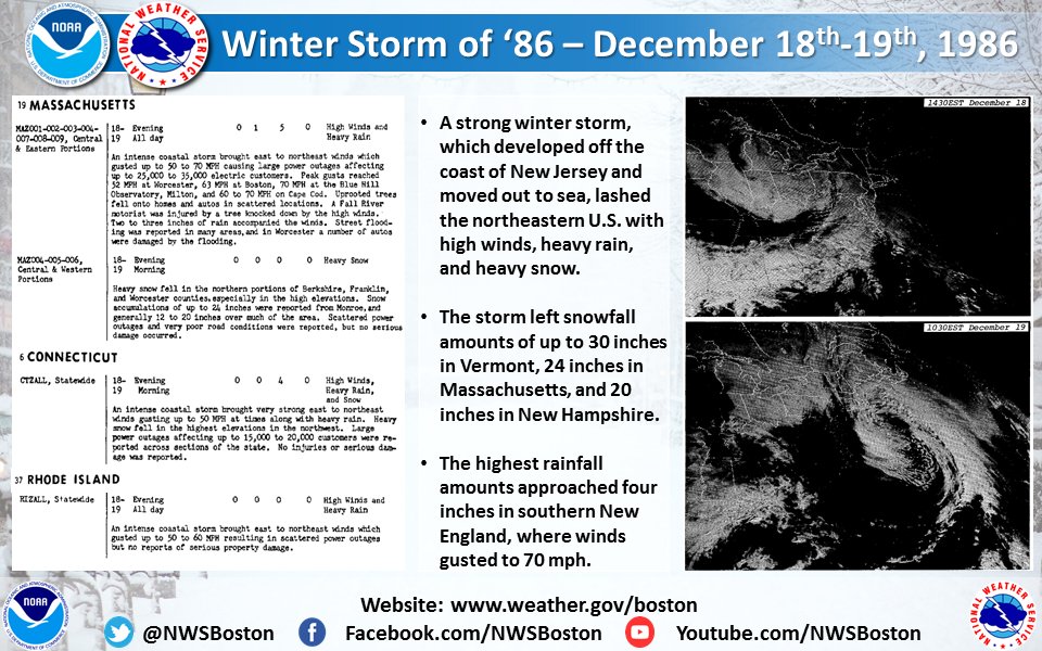
The image above is from a Tweet by the NWS Office in Boston, Massachusetts.
1944: Typhoon Cobra, also known as the Typhoon of 1944 or Halsey's Typhoon (named after Admiral William "Bull" Halsey), was the United States Navy designation for a tropical cyclone that struck the Task Force 38 in the during World War II in the Pacific. The typhoon was first observed on December 17 as it surprised a fleet of ships in the open waters of the western Pacific Ocean. Sustained winds associated with the storm were up to 100 mph with gusts to 140 mph. On December 18, the small but violent typhoon hit the Task Force while many of the ships were attempting to refuel. Due to the extreme seas and winds, three destroyers capsized and went down with practically all hands, while a cruiser, five aircraft carriers, and three destroyers suffered serious damage. Approximately 790 officers and men were lost or killed with another 80 injured. This storm inflicted more damage on the Navy than any storm since the hurricane at Apia, Samoa, in 1889. In the aftermath of this deadly storm, the Pacific Fleet established new weather stations in the Caroline Islands and, as they were secured, Manila, Iwo Jima, and Okinawa. Also, new weather central offices (for coordinating data) were established at Guam and Leyte.

A Navy ship's radar captured the structure of a typhoon on December 18. This storm was
the second tropical storm ever to be observed on radar East of the Philippine Islands.

The U.S. Navy light aircraft carrier USS Langley (CVL-27) rolling heavily during Typhoon
Cobra, 18 December 1944. A battleship is steaming behind the carrier. U.S. Navy

A view of USS Cowpens (CVL-25) starboard side flight deck facing aft from the island. The
photo was taken at the time Typhoon Cobra hit the Third Fleet on 18 December 1944.
1986: A strong winter storm, which developed off the coast of New Jersey and moved out to sea, lashed the northeastern U.S. with high winds, heavy rain, and heavy snow. The storm left snowfall amounts of up to 30 inches in Vermont, 24 inches in Massachusetts, and 20 inches in New Hampshire. The highest rainfall amounts approached four inches in southern New England, where winds gusted to 70 mph.

The image above is from a Tweet by the NWS Office in Boston, Massachusetts.
Re: Weather history miscellany
https://www.weatherforyou.com/weather_history/12-19
1924 - The Riverside Ranger Station in Yellowstone Park, WY, reported a low of 59 degrees below zero, a December record for the U.S. (David Ludlum) (The Weather Channel)
1988 - Low pressure and a trailing cold front in the central U.S. brought snow and high winds to parts of the Rocky Mountain Region. Winds in Colorado gusted to 67 mph at La Junta. Thunderstorms along the same cold front produced wind gusts to 65 mph at Kansas City MO. (The National Weather Summary) (Storm Data)
2008 - A snow and ice storm on December 19 affected parts of the U.S. Midwest. Over 220,000 homes and businesses across Illinois, Indiana, and Ohio were left without electric services. No fatalities were reported (Reuters).
Re: Weather history miscellany
https://www.weather.gov/abr/This_Day_in ... ory_Dec_20
1836: A famous "sudden freeze" occurred in central Illinois. A cold front with 70 mph winds swept through around Noon, dropping the temperature from 40 degrees to near zero in a matter of minutes. Many settlers froze to death. Folklore told of chickens frozen in their tracks and men frozen to saddles. Ice in streams reportedly froze to six inches in a few hours. Click HERE for a presentation from AMS. Click HERE for additional information from a book called History of the early settlers of Sangamon County, Illinois: “Centennial Record.”

1984: Lili, a rare December hurricane, was officially declared a tropical system in the central Atlantic as a distinct eye type feature was apparent on satellite imagery. The hurricane peaked at sustained 80 mph winds and a pressure of 980 millibars or 28.94 inches of mercury, a very respectable Category 1 Hurricane in December.

The image shows Hurricane Lili on December 22, 1984, with winds of 80 mph.
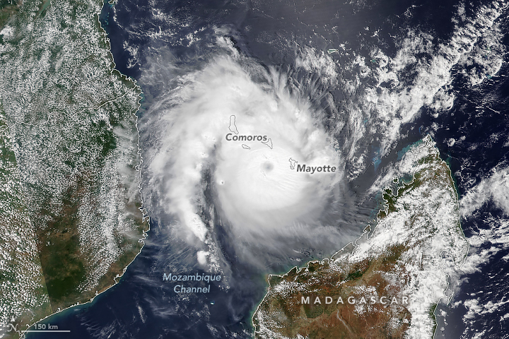
2006: Severe Cyclone Bondo, the equivalent of a Category 4, approaches the Madagascar coast with sustained winds of 138 mph. Click HERE for more information from NASA’s Earth Observatory.
1836: A famous "sudden freeze" occurred in central Illinois. A cold front with 70 mph winds swept through around Noon, dropping the temperature from 40 degrees to near zero in a matter of minutes. Many settlers froze to death. Folklore told of chickens frozen in their tracks and men frozen to saddles. Ice in streams reportedly froze to six inches in a few hours. Click HERE for a presentation from AMS. Click HERE for additional information from a book called History of the early settlers of Sangamon County, Illinois: “Centennial Record.”

1984: Lili, a rare December hurricane, was officially declared a tropical system in the central Atlantic as a distinct eye type feature was apparent on satellite imagery. The hurricane peaked at sustained 80 mph winds and a pressure of 980 millibars or 28.94 inches of mercury, a very respectable Category 1 Hurricane in December.

The image shows Hurricane Lili on December 22, 1984, with winds of 80 mph.
2006: Severe Cyclone Bondo, the equivalent of a Category 4, approaches the Madagascar coast with sustained winds of 138 mph. Click HERE for more information from NASA’s Earth Observatory.
