An incoming winter storm triggered a Winter Storm Warning for the Kaibab Plateau in Arizona in mid-February 2025. Snow began falling on February 13 and continued through February 14, bringing strong winds and a fresh layer of white before skies cleared. Wind gusts of 17 miles per hour (27.4 km/h) were measured at the closest weather station to Kaibab, AZ, on February 14, with less than an inch of new snow added to the ground on that day.
1969: The famous "100-Hour Storm" began in Boston, MA. Snow often fell between early on the 25th and noon on the 28th. The 26.3 inches at Logan Airport is the 2nd most significant snowstorm in Boston's history. In addition, 77 inches fell at Pinkham Notch Base Station in New Hampshire, bringing their February total to 130 inches. Their snow cover on the 27th was 164 inches. Mt. Washington, NH, received 172.8 inches of snow in the month.
A rift on the George VI Ice Shelf remnant was evident in late 2024, but the iceberg-to-be was still hemmed in by sea ice at the Ronne Entrance—the bay that abuts the southern end of the ice shelf. (The George VI is an unusual ice shelf in that it has both a northern and southern ice front.) By January 2025, most of the seasonal sea ice had melted, and ocean currents carried the new iceberg away.
“I’m impressed by how fast it has moved in the coastal current,” said Christopher Shuman, a retired glaciologist with the University of Maryland, Baltimore County. “It makes me wonder just what is happening in the water under the ice shelf.”
Cirrus clouds are high, thin clouds that can take on filament-like forms. They usually form at an altitude of 6,000 meters (20,000 feet) or higher where the air temperature is well below freezing. The clouds are formed when relatively moist, lower-level air is pulled into higher layers, where the air then cools and forms tiny ice crystals. Cirrus clouds, which are made up of these crystals, then spread out and create the finger-like wisps seen in this image.
1987 - A slow moving storm in the southwestern U.S. spread heavy snow from the southern and central Rockies into the Central High Plains Region. Totals in Colorado ranged up to 62 inches at Purgatory. Colorado Springs CO reported a February record of 14.8 inches of snow in 24 hours. Lander WY received four inches in one hour, 13 inches in seven hours, and a record storm total of 26 inches. High winds created near blizzard conditions at Colorado Springs. Fairplay CO reported 43 inches of snow, with drifts ten feet high. (The National Weather Summary) (Storm Data)
1989 - An upper level weather disturbance brought snow to parts of the central U.S. which just one day earlier were enjoying temperatures in the 60s. Snowfall totals in Missouri ranged up to nine inches at Rolla. (The National Weather Summary) (Storm Data)
Every month on Earth Matters, we offer a puzzling satellite image. The February 2025 puzzler is shown above. Your
challenge is to use the comments section to tell us where it is, what we are looking at, and why it is interesting.
Reply here.
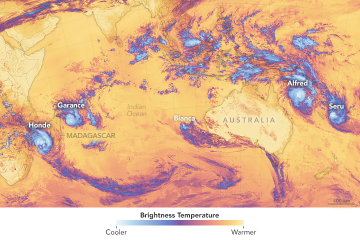
On February 23, 2025, a new tropical cyclone spun up over the Coral Sea off the eastern coast of Queensland, Australia. The new storm, named Tropical Cyclone Alfred by the Australian Bureau of Meteorology (BoM), meandered generally northeastward for a few days, slowly strengthening before turning southward to skirt the Queensland coastline.
By February 26, when the Moderate Resolution Imaging Spectroradiometer (MODIS) on NASA’s Aqua satellite acquired this true-color image, the storm was carrying maximum sustained winds of 100 miles per hour (161 km/h) and was continuing to travel generally southward. Based on windspeed and the strength of gusts, the BoM rated the storm at Category 3 on the Australian tropical cyclone scale, which means a storm carrying very destructive winds that may damage roofs and structures and may bring power failures as well as significant damage to crops and trees.
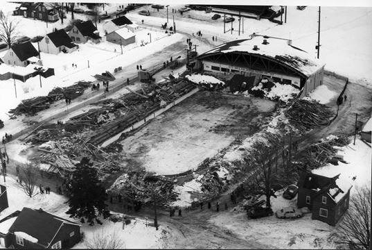
1959: In early December 1958, temperatures fell below freezing and remained there until late February. Over 49 inches of snow fell in that time, with very little in the way of melting. The snow absorbed some rain in February and added to the weight on the roof of the Listowel Arena in Ontario, Canada. As a result, the roof collapsed on February 28, 1959, during a hockey game. Seven young players, a referee, and a recreation director (Reginald Kenneth McLeod) were killed in the tragic collapse. Click HERE for more information.
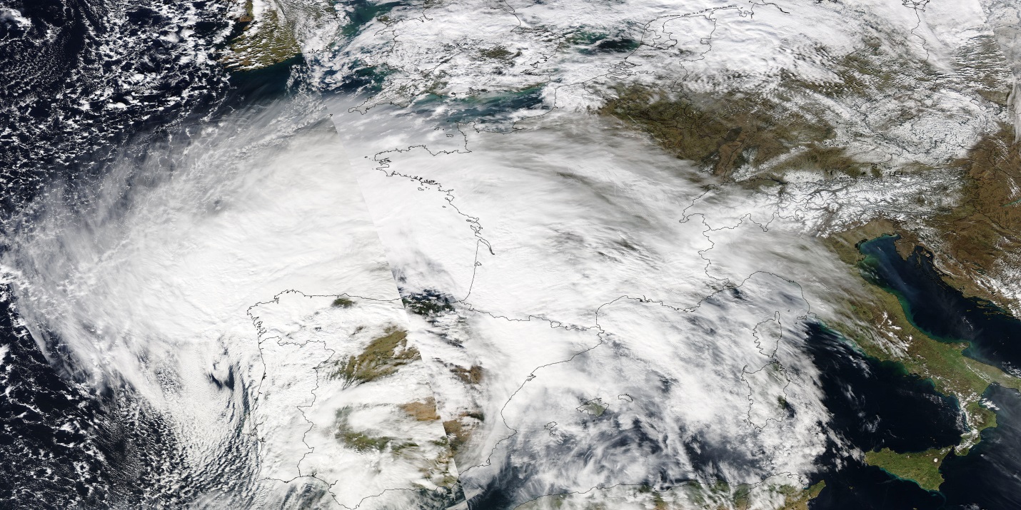
2007: A severe storm named Xynthia blows into France, Portugal, and Spain, smashing sea walls, destroying homes, polluting farmland with salt water, and devastating the Atlantic coast's oyster farms. Winds reach about 125 mph on the summits of the Pyrenees and up to nearly 100 mph along the Atlantic Coast. Wind speeds of 106 mph are measured atop the Eiffel Tower in Paris. The hardest-hit area was in the Vendee and Charente-Maritime regions in southwestern France. The storm is blamed for 52 deaths in France. In addition, a Napoleonic sea wall collapsed off the coastal town of La'Aiguillon-Sur-Mer. A mobile home park close to the sea wall was particularly hard hit. Click HERE for more information from the BBC.
The image depicts infrared signals known as brightness temperature, which are useful for distinguishing cooler cloud structures (white and purple) from the warmer surface below (yellow and orange).
Meteorologists noted that warm sea surface temperatures and weak wind shear conditions may have contributed to the proliferation of storms. A marine heat wave has lingered off of Western Australia since September 2024, and anomalously high sea surface temperatures warmed in the area in late February 2025. For the South Pacific, the Australian Bureau of Meteorology had predicted a higher-than-average likelihood of severe tropical cyclones this season due to expected warm ocean temperatures. Tropical cyclone season generally runs from November through April in the Southern Hemisphere.
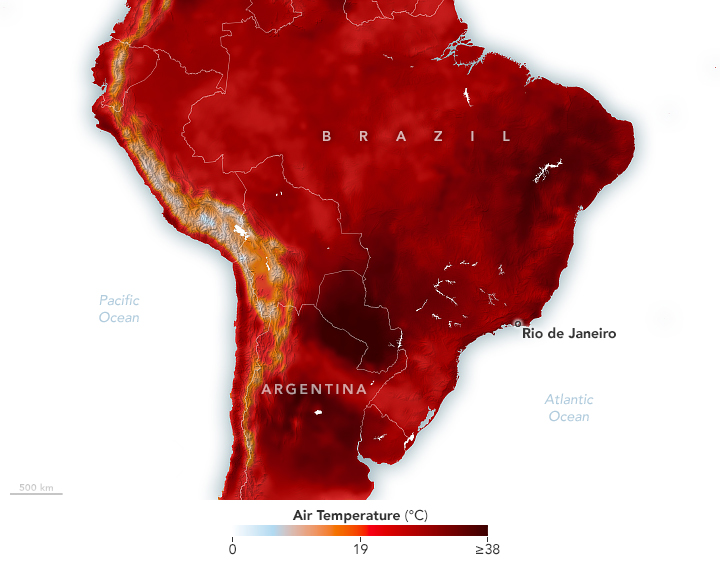
In February 2025, an area of high pressure parked over the southern Atlantic Ocean, causing temperatures to soar in parts of South America. In Brazil, the heat led officials in Rio Grande do Sul to delay the start of school and people in Rio de Janeiro to flock to the beach.
The summer heat wave is depicted on this map, which shows air temperatures modeled at 2 meters (6.5 feet) above the ground on February 17.
The city of Rio de Janeiro saw especially warm conditions on February 17. According to news reports, a weather station in the Guaratiba neighborhood recorded temperatures of up to 44°C that day(111°F)—the hottest temperature measured since the development of the city’s climate alert system 10 years ago.
1849: The first recorded weather observation for Blowing Green, Kentucky, occurred on March 1, 1849.
Here are the data for Bowling Green, Kentucky from the National Centers for Environmental Information/Daily Observations:
STATION_ID
STATION
BEGIN_DATE
END_DATE
STATE
COUNTRY
LATITUDE
LONGITUDE
ELEVATION_(M)
GHCND:USC00150904
"BOWLING GREEN, KY US"
1948-05-31
2025-02-25
Kentucky
United States
36.9987
-86.4276
144.8
I suppose I'll have to make a spreadsheet so we can enter 100 years worth of data for Bowling Green. It makes me wonder how much climate information is waiting to make it into the climate databases.
1927: Raleigh, North Carolina, was buried under 17.8 inches of snow in 24 hours, a record for that location until 2000. On January 25, 2000, Raleigh saw 17.9 inches of snow in 24 hours.
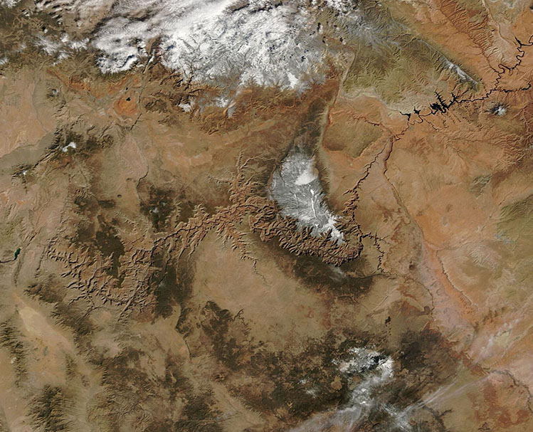
For orientation, Utah’s bi-colored lake, the Great Salt Lake, remains ice-free near the center of the image.
On February 5, the National Integrated Drought Information System (Drought.gov) reported that, to that point, snow drought continued in most of the West, with record dryness in the Southwest (Arizona, Colorado, Nevada, New Mexico, and Utah). The snow drought deepened due to extremely dry conditions across most of the West in January. Several substantial snow events in February improved conditions over most of the region, with most areas reporting snowpack near median near the end of the month.
1991: A significant ice storm coated parts of central and northwestern New York State with up to two inches of ice. The damage totaled $375 million. It was the most costly natural disaster ever in the state up until that time. Nearly half a million people were without power at the height of the storm, and many would not see their power restored until the 16th.
Although much larger and denser plumes occur in this area, the dust in this image stands out due to its distinctive coloration. Sebkhet Te-n-Dghâmcha (also called Sebkha de Ndrhamcha), a seasonal lake and salt pan northeast of Nouakchott, appears to be the source of the lighter-colored dust. The salt pan contains large amounts of gypsum, a white mineral that forms when the lake’s water evaporates.
It is also rich in other white minerals, including calcite and kaolinite, according to Sofía Gómez Maqueo Anaya, an atmospheric scientist at the Leibniz Institute for Tropospheric Research, who studies airborne particles at the Ocean Science Centre Mindelo in Cabo Verde. The darker, more yellow plumes are likely rich in hematite or goethite, iron oxide minerals known for giving dust reddish or yellowish hues.
Dried lakes and rivers are major sources of atmospheric dust because evaporating water typically leaves behind fine-grained particles that are light enough to be lifted. They also tend to lack vegetation, making the particles especially vulnerable to wind-driven erosion and transport.
Once airborne, Saharan dust particles can affect the health of people, both near and far, who breathe them and any pathogens they carry. Also, many plumes cross part or all of the Atlantic Ocean, fueling phytoplankton blooms, fertilizing soils in the Amazon, and influencing the development of hurricanes.
1841: President William Henry Harrison was sworn into office on a cloudy, cold, and blustery day. His speech lasted one hour and 40 minutes, and he rode a horse to and from the Capitol without a hat or overcoat. Unfortunately, he died from pneumonia a month later, or did he? Click HERE for more information from the Smithsonian Magazine.
1873: The second inauguration of Ulysses S. Grant remains Washington, DC's record cold March day. The low was 4 degrees, and by noon with the sunshine, the temperature was 16 degrees. Wind chills were around 30 degrees below zero. The 40 mph winds made his inaugural address inaudible to most on the platform with him. Click HERE for more information from the Library of Congress.
1899: Cyclone Mahina, aka "The Bathurst Bay Hurricane" in Australia, was credited with producing the highest storm surge on record worldwide. The cyclone, with an estimated central pressure of 911 millibars or 26.90 inches of mercury, caused a 42.6-foot surge when it came ashore on the coast of northern Australia. The storm killed as many as 400 people and is Australia's deadliest cyclone.
1983: Brownsville, Texas, recorded a high of 100 degrees, the earliest the city has ever hit the century mark.
The largest wildland fire to burn in Japan in decades spread amid dry, windy conditions in late winter 2025. As of March 3, it had consumed an estimated 2,100 hectares (8.1 square miles) of forested land near Ofunato, a small port city approximately 400 kilometers (250 miles) north of Tokyo.
Wildfires frequently occur in Japan between January and May, when the air is drier, but they tend to be much smaller in size than the one burning in early 2025, according to news reports. However, conditions were unusually dry leading up to this event. Ofunato received only 2.5 millimeters (0.1 inches) of precipitation in February 2025, the lowest monthly total for February in a record going back to 1964. Strong winds that fanned the flames and steep terrain that challenged containment efforts also contributed to this fire’s growth, experts told news outlets.
In addition to burning through forested land, the fire damaged dozens of structures and prompted officials to issue evacuation orders to more than 4,500 people, said FDMA. According to news reports, more than 2,000 firefighters from across the country were deployed to combat the blaze.