Page 15 of 15
Re: Weather history miscellany
Posted: Thu Feb 13, 2025 2:07 pm
by Randi
https://www.weather.gov/abr/This_Day_in ... ory_Feb_13
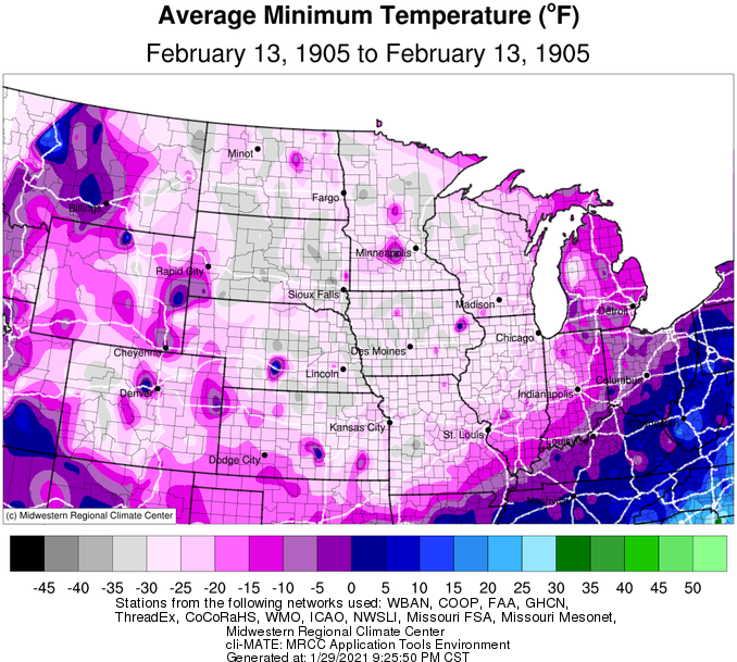
1905: Freezing temperatures were recorded over the states of Oklahoma, Arkansas, Kansas, and Missouri. Morning lows of 29 degrees below zero at Gravette, Arkansas, 40 below at Lebanon, Kansas, and 40 below at Warsaw, Missouri, established all-time records for those three states.
The low temperature at Vinita, Oklahoma, plummeted to 27 degrees below zero. The temperature would be tied at Watts in January 1930 and Blackwell and Medford in February 2011. The negative 27-degree reading is cold enough to be the 2nd lowest temperature on record in Oklahoma. The coldest is currently 31 degrees below zero, recorded at Nowata on February 10, 2011.
1995: A National Weather Service Survey Team concluded a weak (F1) tornado occurred at the General Motors Desert Proving Grounds facility in Mesa, Arizona. Moderate damage was observed. A roof was damaged, and about 20 vehicles were destroyed and moved around. One car was lifted, moved several feet, and set down inside a roped-off area containing solar exposure equipment. The tornado traveled northeast and lasted about five minutes. The image below is from the February 1995 Storm Data.

Re: Weather history miscellany
Posted: Thu Feb 13, 2025 2:20 pm
by Randi
NASA Earth Observatory - 2016
 A Rope Ahead of a Cold Front(November 12, 2015)
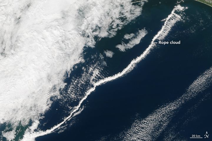
The next time you see a thunderstorm rise up in the distance, take note of the winds. In a few minutes, you will likely notice a cool breeze coming your way. The breeze is evidence of an outflow boundary (or gust front), a term meteorologists use to describe the pools of cool air that tend to spread out ahead of thunderstorms.
A Rope Ahead of a Cold Front(November 12, 2015)
The next time you see a thunderstorm rise up in the distance, take note of the winds. In a few minutes, you will likely notice a cool breeze coming your way. The breeze is evidence of an outflow boundary (or gust front), a term meteorologists use to describe the pools of cool air that tend to spread out ahead of thunderstorms.
From the vantage point of space, outflow boundaries often appear as thin lines of cumulus clouds—sometimes called rope clouds—racing a few kilometers ahead of a front of cooler air.
Re: Weather history miscellany
Posted: Fri Feb 14, 2025 3:05 pm
by Randi
https://www.weather.gov/abr/This_Day_in ... ory_Feb_14
1895: The most significant snowfall in the history of Houston, Texas, occurred on the 14th and 15th. The Houston area saw 20 inches of snow. Click
HERE for more information from Space City Weather.

2007: Light snow fell on Nepal's capital,
Kathmandu, for the first time in over
60 years.
They also saw light snow on February 28th,
2019.
Re: Weather history miscellany
Posted: Fri Feb 14, 2025 3:13 pm
by Randi
MODIS Image of the day
 Tropical Cyclone Zelia(2/13/2025)
Near the time this image was acquired, Zelia was carrying maximum sustained winds of about 160 miles per hour (257 km/h), which is the equivalent of a strong Category 5 hurricane on the Saffir-Simpson Hurricane Wind Scale. ABCNews (Australian Broadcasting Company) reported that the storm was forecast to bring wind gusts of up to 320 kilometers per hour (199 mph).
Tropical Cyclone Zelia(2/13/2025)
Near the time this image was acquired, Zelia was carrying maximum sustained winds of about 160 miles per hour (257 km/h), which is the equivalent of a strong Category 5 hurricane on the Saffir-Simpson Hurricane Wind Scale. ABCNews (Australian Broadcasting Company) reported that the storm was forecast to bring wind gusts of up to 320 kilometers per hour (199 mph).
Re: Weather history miscellany
Posted: Fri Feb 14, 2025 10:07 pm
by pommystuart
Whilst Zelia did cross as a cat 4 and cause a lot of damage it was lucky that it crossed in a relatively sparsely populated area.
“This system is producing very heavy rainfall, with rainfall totals expected to be 200mm to 300mm over the next 24 hours,” Mr Collopy said.
He said it would bring rainfall totals over the next three days of about 500mm, with potential flash flooding in areas including the De Grey River catchment.
Re: Weather history miscellany
Posted: Sat Feb 15, 2025 2:35 pm
by Randi
https://www.weatherforyou.com/weather_history/2-15
1895 - A big Gulf snowstorm produced six inches at Brownsville TX and Mobile AL, 15 inches at Galveston TX, and 24 inches of snow at Rayne LA in 24 hours. Snow fell at the very mouth of the Mississippi River. Houston TX received 22 inches of snow, and nine inches blanketed New Orleans LA. (David Ludlum)
1987 - A storm crossing the central U.S. produced severe thunderstorms which spawned tornadoes in Louisiana and Mississippi. Tornadoes injured four persons at Pierre Pass LA, three persons at Tangipahoa LA, two persons at Lexie MS and two persons at Nicholson MS. Thunderstorm winds gusting to 100 mph killed one person south of Sulphur LA. Jackson MS was drenched with 1.5 inches of rain in ten minutes. (The National Weather Summary) (Storm Data)
1989 - Thirty-seven cities in the southeastern U.S. reported record high temperatures for the date. The afternoon high of 80 degrees at Atlanta GA was a February record. Highs of 79 degrees at Chattanooga TN, 84 degrees at Columbia SC and 85 degrees at New Orleans LA equalled February records. (The National Weather Summary)
Re: Weather history miscellany
Posted: Sat Feb 15, 2025 2:45 pm
by Randi
MODIS Image of the day
 Atmospheric River Strikes Southern California(2/13/2025)
A precipitation-filled atmospheric river struck southern California in mid-February 2025, kicking off the fifth coast-to-coast storm to strike the United States since the start of the new year. Heavy rain drenched much of the region on February 12-14, including areas recently ravaged by wildfires. Local media reported that on February 13 one highway intersection near Pacific Palisades was buried under at least 3 feet (1 meter) of sludge. It was also reported that a road near the Eaton Fire burn scar (near Altadena, California) was covered in “several feet of mud, vegetation and trees” despite a concrete block wall designed to prevent debris flows. Several media outlets showed several cars mired in mud flows.
Atmospheric River Strikes Southern California(2/13/2025)
A precipitation-filled atmospheric river struck southern California in mid-February 2025, kicking off the fifth coast-to-coast storm to strike the United States since the start of the new year. Heavy rain drenched much of the region on February 12-14, including areas recently ravaged by wildfires. Local media reported that on February 13 one highway intersection near Pacific Palisades was buried under at least 3 feet (1 meter) of sludge. It was also reported that a road near the Eaton Fire burn scar (near Altadena, California) was covered in “several feet of mud, vegetation and trees” despite a concrete block wall designed to prevent debris flows. Several media outlets showed several cars mired in mud flows.
The city of Los Angeles, California, is buried under the thickest area of cloud.
https://www.geonames.org/5368361/los-angeles.html
Re: Weather history miscellany
Posted: Sun Feb 16, 2025 2:17 pm
by Randi
https://www.weather.gov/abr/This_Day_in ... ory_Feb_16
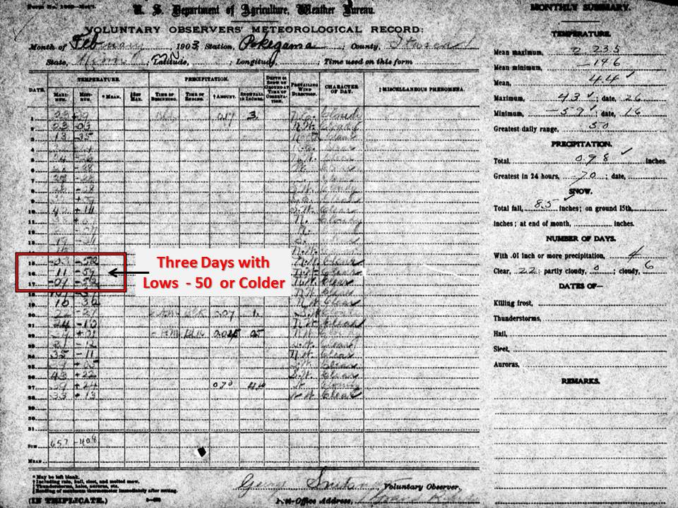
1903: Pokegama Dam, Minnesota saw three straight days with low temperatures 50° below zero or colder, including 59° below zero on the 15th. The minus 59° established a state record for the lowest measured temperature in Minnesota. Pokegama Dam held the record until February 2nd, 1996 when the temperature fell to 60° below zero at Tower.
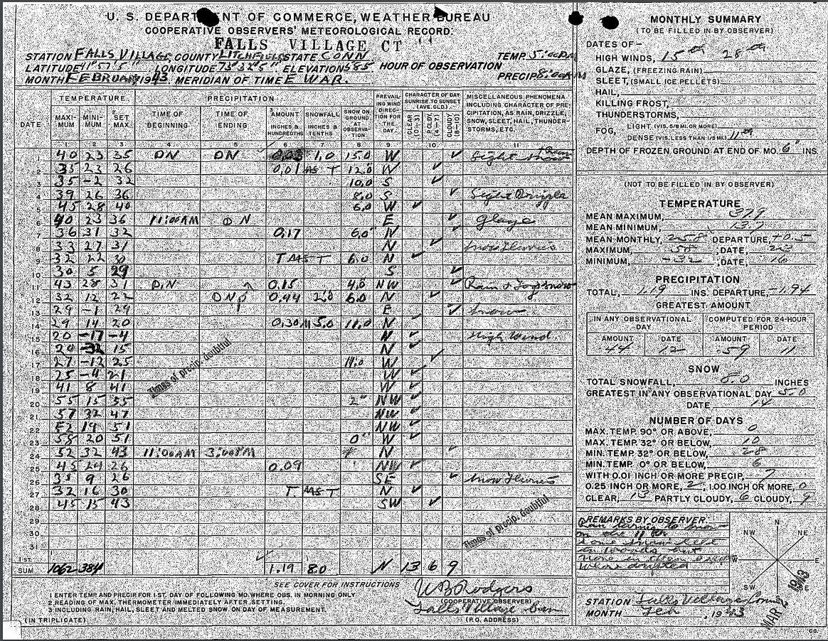
1943: Record cold prevailed in the northeastern United States. The mercury plunged to 37°F below zero at Concord, New Hampshire, and to -39 degrees at Portland, Maine. The morning low of -32°F at Falls Village, Connecticut, established a state record. The Connecticut record low was tied on January 22nd, 1961, when Coventry fell to -32°F.

1989: A surge of arctic air on February 16-17th produced all-time record high barometric pressure readings of 31.08 inches at Duluth, Minnesota, 30.97 inches at Chicago, Illinois, and 30.94 inches at South Bend, Indiana. Readings of 31.00 inches at Milwaukee, Wisconsin, and 30.98 inches at Rockford, Illinois, tied their all-time records. Unseasonably warm weather prevailed across the southeastern U.S. Highs of 81 degrees at Athens, Georgia, 87 degrees at Charleston, South Carolina, 85 degrees at Macon, Georgia, and 86 degrees at Savannah, Georgia, were records for February.
United States & Canada Sea Level Pressure Extremes
Re: Weather history miscellany
Posted: Sun Feb 16, 2025 5:36 pm
by Randi
MODIS Image of the day

December 18, 2024 |

February 12, 2025 |
Massive Burn Scars in Southeastern Australia
The fire in Grampians (Gariwerd) National Park first was reported on December 17, 2024, after dry lightning started several fires in the southern part of the national park, according to the Vic Emergency website. A small dark brown burn scar can be seen in the southeastern section of the park on the December 18 image. By January 6, this bushfire was declared contained. More than 76,000 hectares of national park and agricultural land had burned at that time. Terra MODIS detected hot spots and smoke, indicating active fire, within the contained area as late as February 6.
The fire in Little Desert was also ignited by lightning and was first reported on January 27, 2025. The fire had been fully contained by February 6, according to local media, although some hot spot activity remained on that date within the fire lines. “Containment” means the outside perimeter of the fire has stopped forward motion and growth. It is normal for fire to remain burning within the containment area for some time, as fire crews work to ultimately completely douse the fire.
https://www.geonames.org/8156338/grampi ... -park.html
Re: Weather history miscellany
Posted: Mon Feb 17, 2025 2:20 pm
by Randi
https://www.weatherforyou.com/weather_history/2-17
1987 - A couple of winter storms, one off the Atlantic coast and another over the south central U.S., produced snow and ice from the Mississippi Valley to the Mid Atlantic Coast Region. Freezing rain produced a coat of ice three inches thick in northern South Carolina, and 30,000 homes around Pee Dee were left without electricity. Parts of south central Kentucky were without electricity for three days following the storm, which was their worst in 35 years. (The National Weather Summary) (Storm Data)
1989 - Low pressure off the Washington coast produced more than a foot of snow in the Cascade Mountains, and more than three inches of rain along the Northern Pacific Coast. Spokane WA was blanketed with 13 inches of snow. Cold arctic air in the Upper Midwest produced all-time record high barometric pressure readings of 31.10 inches at Duluth MN, 31.09 inches at Minneapolis MN, and 31.21 inches at Bismarck ND. (The National Weather Summary) (Storm Data)
Re: Weather history miscellany
Posted: Tue Feb 18, 2025 3:08 pm
by Randi
https://www.weather.gov/abr/This_Day_in ... ory_Feb_18
1965: A massive avalanche kills 26 men at the Granduc Copper Mine in British Columbia on this day. Click
HERE for more information from the History Channel.
Re: Weather history miscellany
Posted: Tue Feb 18, 2025 3:13 pm
by Randi
Re: Weather history miscellany
Posted: Wed Feb 19, 2025 1:54 pm
by Randi
https://www.weatherforyou.com/weather_history/2-19
1987 - A winter storm over the southern and central Rockies produced 28 inches of snow at Echo Lake CO, and two feet of snow at Gascon NM and Los Alamos NM. Mora County NM was declared a disaster area following the storm. (The National Weather Summary) (Storm Data)
1989 - An upper level weather disturbance brought heavy snow to parts of Nebraska, with six inches reported at Loup City and Surprise. (The National Weather Summary) (Storm Data)
Re: Weather history miscellany
Posted: Wed Feb 19, 2025 2:04 pm
by Randi
NASA Earth Observatory
 January 24, 2025
 |
 February 17, 2025
 |
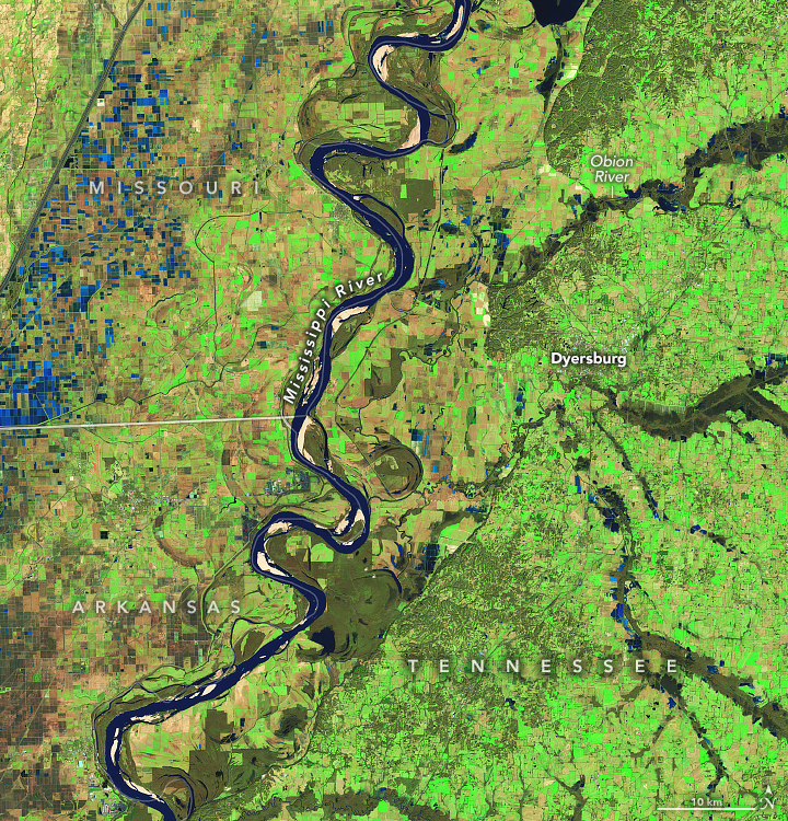
Floods Swamp Tennessee
A powerful storm system moved across the U.S. Southeast on February 15-16, bringing damaging winds, torrential rains, and destructive flash floods to several communities in Tennessee and Kentucky.
Many areas received up to 6 inches (15 centimeters) of rain over a 48-hour period, according to the National Weather Service. Government data indicate that water levels in multiple rivers in the two states faced moderate to major flooding.
https://www.geonames.org/4619800/dyersburg.html
Re: Weather history miscellany
Posted: Fri Feb 21, 2025 12:41 am
by Randi
https://www.weather.gov/abr/This_Day_in ... ory_Feb_20
1995: The temperature at the Civic Center in Los Angeles, California, soared to 95 degrees, the highest ever recorded at the location during February.
Re: Weather history miscellany
Posted: Fri Feb 21, 2025 2:26 pm
by Randi
https://www.weather.gov/abr/This_Day_in ... ory_Feb_21
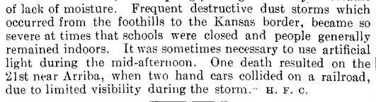
1935: Frequent dust storms occurred in eastern Colorado during the month, forcing schools to close and people to stay indoors. A fatality happened on this date when two section cars collided on the railroad near Arriba Colorado due to poor visibility.

2013: An astonishing 515 cm (202.8" or almost 17') level of snow depth was measured at Sukayu Onsen, Aomori on Honshu Island in Japan, on February 21, 2013, the deepest snow measured at an official weather site in Japan records. (Last Updated in 2020). Click
HERE for more information from Weather Underground.
Re: Weather history miscellany
Posted: Fri Feb 21, 2025 2:37 pm
by Randi
MODIS Image of the day
 Iceberg A23A Approaching South Georgia Island(2/20/2025)
The iceberg appears to have made little forward progress towards South Georgia Island since it was last featured as a MODIS Image of the Day on January 17, 2025. It also remains nearly the same size. According to data published on February 20 by the U.S. National Ice Center, A23A currently measures about 46 x 37 miles, giving it a surface area of about 1,702 square miles, which is larger than the state of Rhode Island. It is located roughly 150 miles away from South Georgia Island, which is nearly the same as the view published on January 17. The January Aqua MODIS true-color image and caption can be viewed by clicking here.
Iceberg A23A Approaching South Georgia Island(2/20/2025)
The iceberg appears to have made little forward progress towards South Georgia Island since it was last featured as a MODIS Image of the Day on January 17, 2025. It also remains nearly the same size. According to data published on February 20 by the U.S. National Ice Center, A23A currently measures about 46 x 37 miles, giving it a surface area of about 1,702 square miles, which is larger than the state of Rhode Island. It is located roughly 150 miles away from South Georgia Island, which is nearly the same as the view published on January 17. The January Aqua MODIS true-color image and caption can be viewed by clicking here.
The position of the giant iceberg so close to South Georgia Island has raised concerns that the ‘berg may strike the island or ground itself on shallow ground close to the island. Either could negatively impact sensitive species such as penguins and seals that breed on South Georgia Island. While grounding appears to be at least a possibility, it is by no means a certainty. A23A remains in currents that could carry it around the island to the relatively warmer waters of the Southern Ocean, where it would be expected to melt. Scientists will continue to closely monitor the movement of this massive iceberg over the next several months.
https://www.geonames.org/3426223/south-georgia.html