Page 12 of 12
Re: Weather history miscellany
Posted: Mon Jan 13, 2025 3:13 pm
by Randi
MODIS - 2019
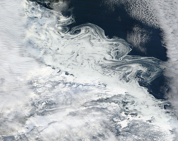
 Clouds and eddies off of Newfoundland and Labrador, Canada( 1/9/201)
Between the banks of clouds, clear skies allow visualization of a peculiar pattern of bright white swirls just off the coast. While these appear to be white clouds, they are almost certainly actually formed by ice caught in the offshore eddies caused by the Labrador Current. The Labrador Current flows from the Arctic Ocean southward along the coast of Labrador and around Newfoundland to the east coast of Nova Scotia.
Each year, Arctic sea ice grows through the winter, reaching its maximum extent around March. It then melts through the summer, reaching its minimum in September. By January, Arctic freeze-up is well underway in many locations, such as off the coast of Labrador and Newfoundland. As ice begins to freeze, it remains malleable and can easily break into many small fragments. Such fragments can be stirred by ocean currents into cyclone-shaped vortices that may range in size from a few hundred feet to a few hundred miles in diameter. Ice eddies are most common in the spring and fall months when the ice is warm enough to fragment, but cold enough to remain frozen as it is moved by the ocean current.
https://www.geonames.org/5969825/hamilton-inlet.html
Re: Weather history miscellany
Posted: Tue Jan 14, 2025 2:28 pm
by Randi
https://www.weather.gov/abr/This_Day_in ... ory_Jan_14
2009: In Washington State, freezing fog and freezing drizzle enveloped much of the Inland Northwest during 13-23 January 2009. The area most affected by this was the high plateau region along Highway 2 between
Wenatchee and
Spokane. Click
HERE for more information from the NWS Office in Spokane, Washington.

Re: Weather history miscellany
Posted: Tue Jan 14, 2025 2:40 pm
by Randi
MODIS Image of the day
 Tropical Cyclone Dikeledi(1/13/2025)
Dikeledi formed in the southern Indian Ocean early in 2025, and on January 9 it was located about 1,700 kilometers (1,056 miles) east of northeastern Madagascar and it was at tropical storm strength, according to the Global Disaster Alert and Coordination System (GDACS). On January 11, it made landfall on northern Madagascar between Antsiranana in the Diana Region and Vohemar in the Sava region as a tropical cyclone carrying maximum sustained winds of about 90 miles per hour (145 km/h), which is equivalent to a Category 1 storm on the Saffir Simpson Hurricane Wind Scale. Tropical Cyclone Dikeledi then passed south of the French Island of Mayotte island on January 12, bringing heavy winds, roaring seas, and drenching rain to the region, which was still recovering from the devastation brought by Tropical Cyclone Chido in early December 2024.
After landfall over Mozambique, Dikeledi weakened but has retained the equivalent wind speeds of a weak Category 1 hurricane. By January 14, it is expected to cross the Mozambique coast once again, this time bringing it offshore and over the Mozambique channel. Current models forecast the storm will track southeast as it strengthens, passing off the southern coast of Madagascar between January 15 and 16. It is not currently forecast to make landfall, although the southern coast could experience wind, rain, and storm surge as Dikeledi passes.
https://www.geonames.org/1033354/nampula.html
Re: Weather history miscellany
Posted: Wed Jan 15, 2025 1:07 pm
by Randi
https://www.weatherforyou.com/weather_history/1-15
1987 - A powerful storm over the Southern Plateau and the Southern Rockies produced 24 inches of snow at Colorado Springs CO, including 22 inches in 24 hours, a January record. High winds in the southwestern U.S. gusted to 65 mph in the Yosemite Valley of California. (National Weather Summary) (Storm Data)
1989 - A storm in the northwestern U.S. produced up to 14 inches of snow in the Cascade Mountain Range. Light snow in the north central U.S. was just enough to push the snowfall total for January at Fargo ND past their previous all-time monthly record of 30.7 inches.
Re: Weather history miscellany
Posted: Wed Jan 15, 2025 1:57 pm
by Randi
MODIS Image of the day

September 4, 2024

January 2, 2025

January 12, 2025
Burn Scars in Southern California
In the January 12 image, at least five large burn scars are visible. This includes the Palisades fire, north of Los Angeles and along the Pacific Coast, the Eaton Fire near the mountains northeast of northern Los Angeles, the larger scar of the Bridge and the Vista fires east of the Eaton Fire in the Angeles National Forest, and the Line Fire in the mountains south of the Bridge Fire. Several burn scars in the southwest appear to be from prescribed burns, according to data from InciWeb.
Clicking on the January 2 image deletes the Palisades Fire and the Eaton Fire, but each of the other scars are present. When the September 4 image is clicked, it reveals a very different view. Most of the landscape is green and scar-free, especially in the locations that had been burnt so dramatically in the more recent images. A few recent burn scars can be seen in the northeast, and one bright red area in the southwest suggests a fresh scar or perhaps an ongoing fire. In some areas, faint remnants of burn scars which have been nearly filled with vegetation can also be seen.
Re: Weather history miscellany
Posted: Thu Jan 16, 2025 2:12 pm
by Randi
https://www.weatherforyou.com/weather_history/1-16
1831 - A great snowstorm raged from Georgia to Maine. Snowfall totals greater than 30 inches were reported from Pennsylvania across southern New England. (David Ludlum)
1987 - A winter storm produced a total of 61 inches of snow at Rye CO, and wind gusts to 100 mph in Utah. The storm then spread heavy snow from the Texas panhandle to Indiana. Tulia TX received 16 inches of snow, and up to 14 inches was reported in western Oklahoma. (National Weather Summary) (Storm Data)
1989 - Strong chinook winds plagued much of the state of Wyoming. Winds gusted to 80 mph at Cody, and wind gusts to 100 mph were reported in eastern and northwestern Wyoming. (National Weather Summary) (Storm Data)
Re: Weather history miscellany
Posted: Thu Jan 16, 2025 2:22 pm
by Randi
MODIS Image of the day
 Dust Storm in the Taklamakan Desert(1/14/2025)
On January 14, 2025, thick dust filled the eastern Taklamakan Desert, creating a rippling tan cloud that was so thick it obscured the ground from view.
Located in the arid Tarim Basin in western China, the Taklamakan Desert received no more than 10 millimeters (0.4 inches) of rain each year. Very few plants can survive in the searing heat and parched conditions, and without vegetation to hold sand in place, any strong wind can raise huge dust storms. About 85 percent of the Taklimakan consists of soaring sand dunes that can reach 200-300 meters (650 to 900 feet) high. These dunes shift position over time, pushed by the frequent winds.
https://www.geonames.org/1279934/takla- ... esert.html
Re: Weather history miscellany
Posted: Fri Jan 17, 2025 2:36 pm
by Randi
https://www.weather.gov/abr/This_Day_in ... ory_Jan_17
1837: The green flash was first documented by Captain Back of the H. M. S. Terror while in the Arctic during 1836-1837. He wrote: “In the morning, however, at a quarter before ten o'clock while standing on an ice hummock about 17 feet high, and looking toward the east, I had observed the upper limb of the sun, as it filled a triangular cleft on the ridge of the headland, of the most brilliant emerald color, a phenomenon which I had not witnessed before in these regions.” Click
HERE for more information about green flashes from
EarthSky.org.
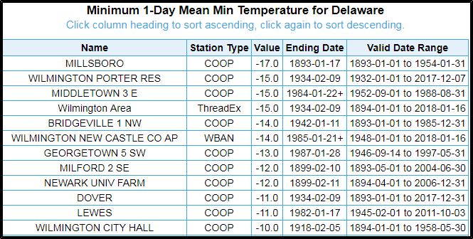
1893: Delaware's coldest temperature of -17 F occurred on January 17th, 1893, in Millsboro.


