Weather history miscellany

Life and death at sea and in the Arctic
User avatar
Randi
Posts: 6771
Joined: Sat Mar 14, 2020 6:53 pm
Location: Pennsylvania

Re: Weather history miscellany

Post by Randi »

NASA Earth Observatory


Phytoplankton Flourish in Patagonian Waters(December 28, 2024)

In this scene, chlorophyll-rich diatoms and other phytoplankton types that color the water green may be giving way to coccolithophores,
said Ivona Cetinić, an oceanographer at Morgan State University and member of NASA’s Ocean Ecology lab.
Armored with plates of highly reflective calcium carbonate, these organisms make surface waters appear a milky turquoise-blue.
The distribution of colors in the image also reveals complexities in the ocean’s surface waters. “Plankton cannot swim against currents,” Cetinić said, “so the different stripes of color indicate many different water masses containing different levels of elements needed for the growth of different phytoplankton types.”


https://www.geonames.org/3474414/falkland-islands.html
User avatar
Randi
Posts: 6771
Joined: Sat Mar 14, 2020 6:53 pm
Location: Pennsylvania

Re: Weather history miscellany

Post by Randi »

https://www.weatherforyou.com/weather_history/1-4

1971 - A blizzard raged from Kansas to Wisconsin, claiming 27 lives in Iowa. Winds reached 50 mph, and the storm produced up to 20 inches of snow. (David Ludlum)

1987 - A storm moving off the Pacific Ocean spread wintery weather across the southwestern U.S., with heavy snow extending from southern California to western Wyoming. Up to 15 inches of snow blanketed the mountains of southern California, and rainfall totals in California ranged up to 2.20 inches in the Chino area. (National Weather Summary) (Storm Data)

1989 - Up to a foot of snow blanketed the mountains of West Virginia, and strong winds in the northeastern U.S. produced wind chill readings as cold as 60 degrees below zero in Maine. Mount Washington NH reported wind gusts to 136 mph along with a temperature of 30 below zero! (National Weather Summary)
User avatar
Randi
Posts: 6771
Joined: Sat Mar 14, 2020 6:53 pm
Location: Pennsylvania

Re: Weather history miscellany

Post by Randi »

MODIS Image of the day


Springtime in the Rio de la Plata(1/2/2025)

In this image, the Uruguay River can be seen carrying dark sediment from the north while the Paraná spreads into several branches as it winds through dark green wetlands. Both rivers appear swollen and exceptionally sediment-laden, most likely the result of flooding that occurred in northern Argentina in mid-December 2024.

https://www.geonames.org/3426221/rio-de-la-plata.html
User avatar
Randi
Posts: 6771
Joined: Sat Mar 14, 2020 6:53 pm
Location: Pennsylvania

Re: Weather history miscellany

Post by Randi »

https://www.weatherforyou.com/weather_history/1-6

1987 - A storm moving across the western U.S. spread heavy snow into the Central Rockies. Casper WY received 14 inches of snow in 24 hours, a January record for that location. Big Piney WY reported 17 inches of snow. (National Weather Summary) (Storm Data)

1989 - A "bonafide blizzard" ripped through south central and southeastern Idaho. Strong winds, gusting to 60 mph at the Fort Hall Indian Reservation, whipped the snow into drifts five feet high, and produced wind chill readings as cold as 35 degrees below zero. The blizzard prompted an Idaho Falls air controller to remark that "the snow is blowing so hard you can't see the fog".(National Weather Summary) (Storm Data)
User avatar
Randi
Posts: 6771
Joined: Sat Mar 14, 2020 6:53 pm
Location: Pennsylvania

Re: Weather history miscellany

Post by Randi »

MODIS - 2016


Fallstreak clouds over Louisiana and Mississippi(12/29/2015)

Fallstreak clouds, which are also called hole-punch clouds, usually appear as circular gaps in decks of altocumulus clouds;
canal clouds look similar but the gaps are longer and thinner.
Both types of cloud form when aircraft fly through cloud decks rich with supercooled water droplets and produce aerodynamic contrails.
Air expands and cools as it moves around the wings and past the propeller, a process known as adiabatic cooling. Air temperatures over
jet wings often cool by as much as 20˚C, pushing supercooled water droplets to the point of freezing.


https://www.geonames.org/4315588/baton-rouge.html
User avatar
Randi
Posts: 6771
Joined: Sat Mar 14, 2020 6:53 pm
Location: Pennsylvania

Re: Weather history miscellany

Post by Randi »

https://www.weather.gov/abr/This_Day_in ... ory_Jan_07

1989: Empty foundations are all that remain of four homes on the southwest end of Allendale, Illinois after an F4 tornado ripped through. The tornado was extremely rare due to its strength and the fact that it occurred so far north during the middle of meteorological winter.
User avatar
Randi
Posts: 6771
Joined: Sat Mar 14, 2020 6:53 pm
Location: Pennsylvania

Re: Weather history miscellany

Post by Randi »

NASA Earth Observatory


October 11, 2024

December 30, 2024
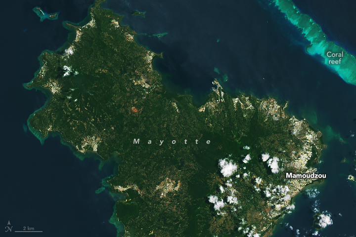
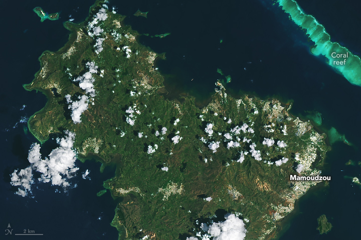
Cyclone-Damaged Mayotte

High winds blow leaves off trees and snap branches, and heavy rain and wind make it easier for trees to be uprooted from wet soils. Trees at high elevations and on steep slopes are more likely to be damaged in storms because they are more exposed to high wind speeds.
Agence France-Presse reported that during Cyclone Chido, a 300-year-old giant baobab in Mayotte collapsed onto a restaurant, and a 3-meter (10-foot) mound of soil now looms where an acacia tree was uprooted by the storm. Banana trees and other crops were destroyed in the storm, according to a humanitarian assessment, putting the island communities’ food supply at risk.


https://www.geonames.org/1024031/mayotte.html
User avatar
Randi
Posts: 6771
Joined: Sat Mar 14, 2020 6:53 pm
Location: Pennsylvania

Re: Weather history miscellany

Post by Randi »

https://www.weather.gov/abr/This_Day_in ... ory_Jan_08

1973: Georgia's worst ice storm since 1935 occurred from the 7th through the 8th. Freezing rain and sleet began during the early morning hours on Sunday the 7th and ended in most areas on Monday. Total damage was estimated at well over $25 million. The electric power companies suffered losses estimated at $5 million, and telephone companies had another $2 million in damages. Some schools were closed for more than a week. Click HERE to see a video from WAGA-TV Channel 5 on this ice storm.

2019: An unusual January tornado impacted Cortland, Ohio, during the mid-morning hours. The EF-1 tornado developed northeast of Champion Township in Trumbull County and moved east. The tornado brought down numerous trees and wires along the 4.5-mile path. Click HERE for more information from the NWS Office in Cleveland, Ohio.
User avatar
Randi
Posts: 6771
Joined: Sat Mar 14, 2020 6:53 pm
Location: Pennsylvania

Re: Weather history miscellany

Post by Randi »

NASA Earth Observatory


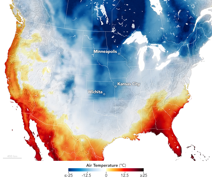
Cold and Snow Wallop the U.S.(January 6, 2025)

The map was derived from the GEOS (Goddard Earth Observing System) model and represents air temperatures at 2 meters (about 6.5 feet) above the ground.

User avatar
Randi
Posts: 6771
Joined: Sat Mar 14, 2020 6:53 pm
Location: Pennsylvania

Re: Weather history miscellany

Post by Randi »

https://www.weather.gov/abr/This_Day_in ... ory_Jan_09

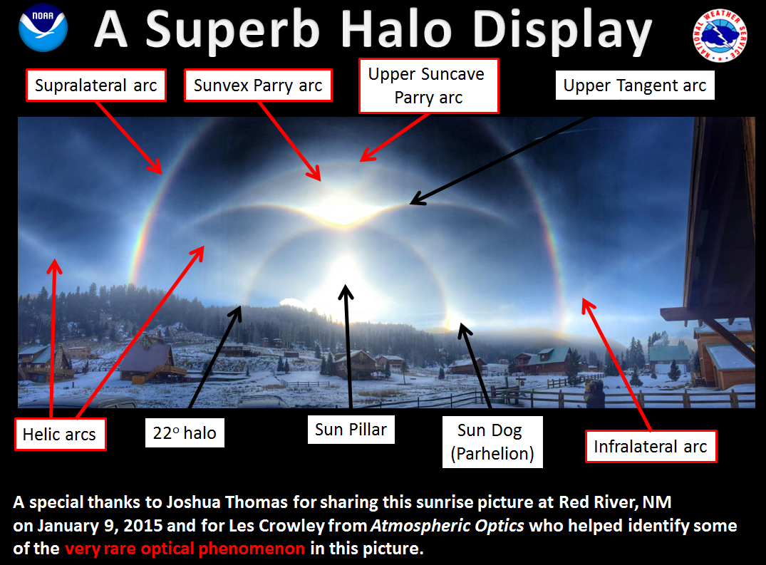
2015: The halo picture below was taken by Texan Joshua Thomas in Red River, New Mexico. Click HERE for the Facebook post by the NWS Office in Amarillo, Texas.
User avatar
Randi
Posts: 6771
Joined: Sat Mar 14, 2020 6:53 pm
Location: Pennsylvania

Re: Weather history miscellany

Post by Randi »

NASA Earth Observatory - 2013


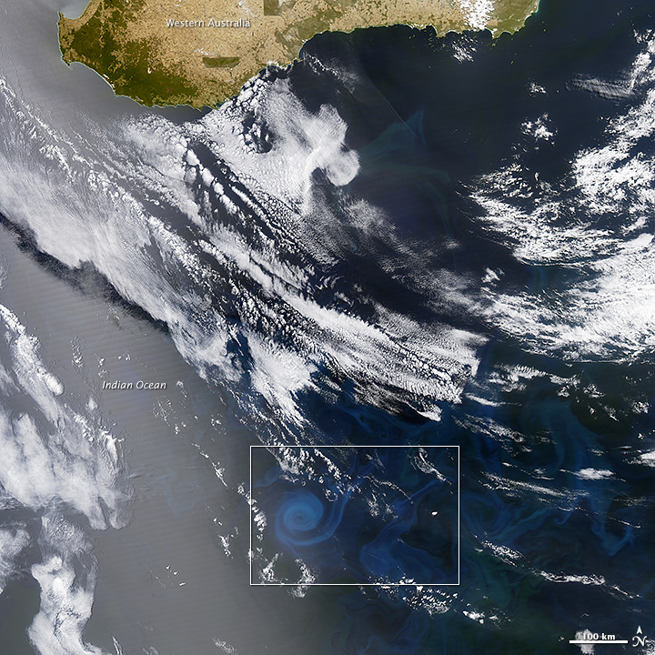
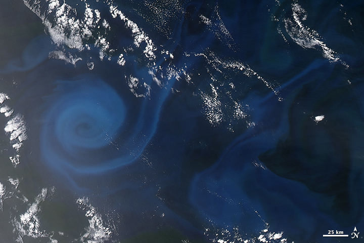
Spiral of Plankton(December 30, 2013)

Like land-based plants, phytoplankton require sunlight, water, and nutrients to grow. Sunlight is now abundant in the far southern latitudes, so nutrients are the limiting variable to phytoplankton growth. Open waters of the ocean can appear relatively barren compared to the nutrient-rich waters near the world’s coasts. In the case of the bloom above, the nutrients may have been supplied by the churning action of ocean currents.
As the close-up image shows, an eddy is outlined by a milky green phytoplankton bloom. Eddies are masses of water that typically spin off of larger currents and rotate in whirlpool-like fashion. They can stretch for hundreds of kilometers and last for months. As these water masses stir the ocean, they can draw nutrients up from the deep, fertilizing the surface waters to create blooms in the open ocean. Other times, they carry in nutrients spun off of other currents.


https://www.geonames.org/2058645/state- ... ralia.html
User avatar
pommystuart
Posts: 1862
Joined: Mon May 18, 2020 12:48 am
Location: Cooranbong, NSW, Australia.

Re: Weather history miscellany

Post by pommystuart »

Your two Friday pics were great.
:kangaroo:
User avatar
Randi
Posts: 6771
Joined: Sat Mar 14, 2020 6:53 pm
Location: Pennsylvania

Re: Weather history miscellany

Post by Randi »

Thanks!
User avatar
Randi
Posts: 6771
Joined: Sat Mar 14, 2020 6:53 pm
Location: Pennsylvania

Re: Weather history miscellany

Post by Randi »

https://www.weather.gov/abr/This_Day_in ... ory_Jan_10

1949: Snow was reported in San Diego, California, for the first time since 1882. The snow was noted on some of the beaches in parts of the Los Angeles metropolitan area. Click HERE for more information from scvhistory.com.

1973: A powerful F5 tornado struck San Justo, a town in the province of Santa Fe, Argentina, on January 10, 1973. At least 63 people were reported dead, and 350 were reported injured as it cut a 300-yard wide swath through the town.
https://www.geonames.org/3836276/santa-fe-province.html
User avatar
Randi
Posts: 6771
Joined: Sat Mar 14, 2020 6:53 pm
Location: Pennsylvania

Re: Weather history miscellany

Post by Randi »

NASA Earth Observatory


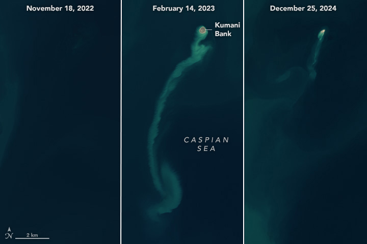
Satellites Spot a “Ghost” Island

An island emerged from the Caspian Sea after a mud volcano erupted in early 2023. By the end of the following year, it had nearly eroded away, retreating from view like an apparition. Powerful eruptions of the Kumani Bank mud volcano have produced similar transient islands several times since its first recorded eruption in 1861. Also known as Chigil-Deniz, the feature is located about 25 kilometers (15 miles) off the eastern coast of Azerbaijan.
On Earth, Azerbaijan is unusual for its high concentration of mud volcanoes. Geologists have tallied more than 300 in eastern Azerbaijan and offshore in the Caspian Sea, with most of those occurring on land. The region falls within a convergence zone where the Arabian and Eurasian tectonic plates are colliding.
Mud volcano eruptions can be hazardous, with the potential to expel large amounts of material—and even flames—over a short period of time. Azerbaijan’s mud volcanoes are linked to the South Caspian Basin’s vast hydrocarbon system and are known to emit flammable gases such as methane along with the characteristic muddy slurries. It is uncertain if the 2023 Kumani Bank eruption was fiery, but past eruptions of this and other nearby mud volcanoes have sent towers of flame hundreds of meters into the air.


https://www.geonames.org/400229/kumani-sayi.html
Post Reply

Return to “The voyages, the work, the people, the places”