Weather history miscellany
Re: Weather history miscellany
https://www.weather.gov/abr/This_Day_in ... ory_Dec_26
1776: George Washington crossed the ice-clogged Delaware River. He marched on Trenton in the midst of snow and sleet thus surprising and captured many of the British garrisons.
2004: A magnitude 9.1 earthquake near Sumatra, Indonesia generated a tsunami that caused tremendous devastation throughout the Indian Ocean. The quake, which is the third largest in the world since 1900, caused severe damage and casualties in northern Sumatra, Indonesia, and in the Nicobar Islands, India. The tsunami that followed killed more people than any other tsunami in recorded history, with 227,898 dead or missing. The total estimated material losses in the Indian Ocean region were $10 billion, and insured losses were $2 billion.
Re: Weather history miscellany
NASA Earth Observatory
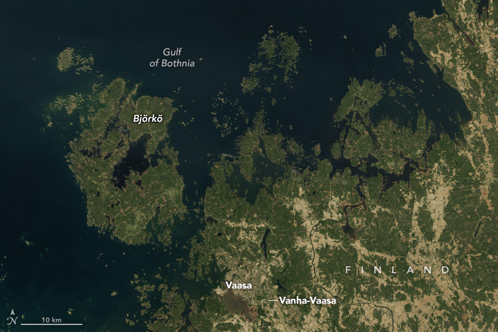
Uplift Underway in Finland’s Kvarken Archipelago(May 29, 2024)
Some 20,000 years ago, during the Last Glacial Maximum, the Baltic Sea sat under a sheet of ice as thick as 3,000 meters (10,000 feet). Scientists estimate that the weight of that ice pressed the land down more than 500 meters (1,600 feet). Since the glaciers receded and the weight was lifted, the land has been bouncing back. The rates of uplift, known as glacial isostatic adjustment or isostatic rebound, in this region are among the highest on Earth. By one estimate, 700 hectares of new land—about twice the size of Central Park in New York City—rise from the sea each year along the coast of the Gulf of Bothnia, the Baltic Sea’s northern arm.
The constant emergence of new land after the ice’s disappearance affected how people ultimately developed the area. For example, the land on which the town of Vaasa was founded was a forested island in the early 14th century. The island later merged with the mainland, and Vaasa grew throughout the 17th and 18th centuries as a thriving harbor and trading point. Still, the land continued to rise, causing the coastline to migrate farther and farther from the town. In August 1852, a napping peddler’s pipe ignited a fire that destroyed much of the settlement. Officials took the opportunity to reestablish Vaasa about 6 kilometers (4 miles) to the west to make it a coastal city once again. Remnants of the original town are preserved in “Old Vaasa” (or Vanha-Vaasa).
https://www.geonames.org/632978/vaasa.html
- pommystuart
- Posts: 1862
- Joined: Mon May 18, 2020 12:48 am
- Location: Cooranbong, NSW, Australia.
Re: Weather history miscellany
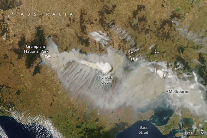
An image from the 20th Dec 2024 from Downunder of a fire that is still burning today (27th)
As of late yesterday the fire raging in Victoria's Grampians has swelled to nearly 80,000 hectares in size, as cooler temperatures bring some relief to firefighters on the front line.
https://earthobservatory.nasa.gov/image ... r-victoria
As of late yesterday the fire raging in Victoria's Grampians has swelled to nearly 80,000 hectares in size, as cooler temperatures bring some relief to firefighters on the front line.

https://earthobservatory.nasa.gov/image ... r-victoria
Re: Weather history miscellany
https://www.weatherforyou.com/weather_history/12-27
1892 - An Atlantic coast storm produced a record 18.6 inches of snow at Norfolk, VA, including 17.7 inches in 24 hours. The storm also produced 9.5 inches of snow at Raleigh NC, and brought snow to northern Florida for the first time in 35 years. (26th- 28th) (The Weather Channel)
1982 - The worst Louisiana rainstorm in more than 100 years came to an end. More than 18 inches fell at Vinton, LA, during the three day storm. Flooding was widespread, and property damage was estimated at 100 to 200 million dollars. President Reagan visited the state and declared ten parishes in northeastern Lousiana disaster areas. (The Weather Channel)
2004 - A major storm system affected parts of the western United States during December 27-29, bringing a variety of weather conditions to the region. Heavy rainfall broke daily precipitation records at some locations in California. Very heavy snow fell across the Sierra Nevada Mountains, with some areas receiving several feet of accumulation. Winds with this weather system gusted over 65 mph at some coastal and mountain locations in California.
Re: Weather history miscellany
NASA Earth Observatory - 2018
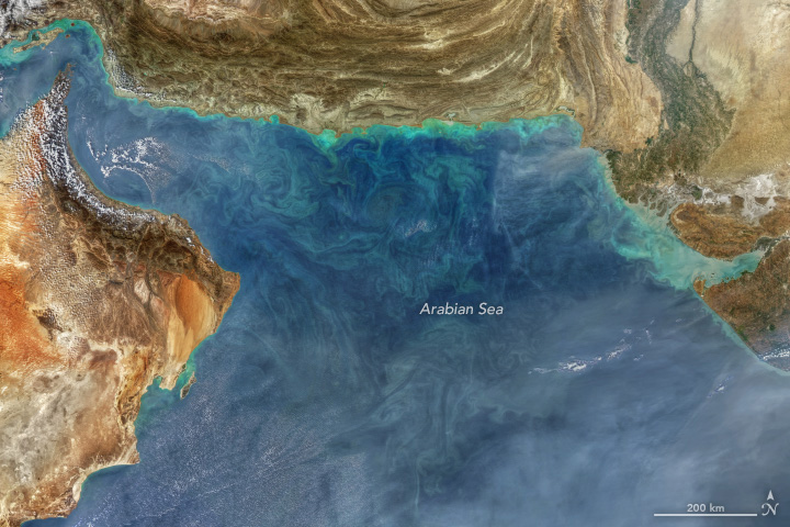
Watercolor Painting of Water Colors(November 23, 2018)
The image appears like a watercolor painting—a blend of art and science. Like a photographer adjusting lighting and using filters, Norman Kuring of NASA’s Ocean Biology group works with various software programs and color-filtering techniques to draw out the fine details in the water. The detailed swirls in the chlorophyll-rich water are all quite real; Kuring simply separates and enhances certain shades and tones in the MODIS data to make the biomass more visible.
https://www.geonames.org/121868/darya-ye-oman.html
Re: Weather history miscellany
https://www.weatherforyou.com/weather_history/12-28
1924 - Iowa experienced it coldest December morning of record. Morning lows averaged 25 degrees below zero for the 104 weather stations across the state.
1958 - Albuquerque, NM, received 14.2 inches of snow to establish a 24 hour record. (28th-29th) (The Weather Channel)
1988 - Strong winds behind a cold front claimed three lives in eastern Pennsylvania, and injured a dozen others in eastern Pennsylvania, southern New Jersey and Maryland. Winds gusted to 87 mph at Hammonton NJ and in the Washington D.C. area. (The National Weather Summary) (Storm Data)
2004 - Los Angeles (downtown) broke a daily rainfall record for the month of December (5.55 inches). This was the third wettest calendar day in Los Angeles since records began in 1877.
Re: Weather history miscellany
NASA Earth Observatory - 2014
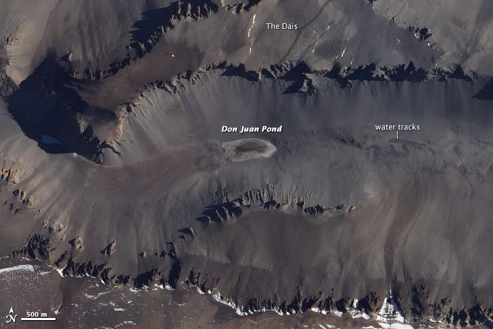
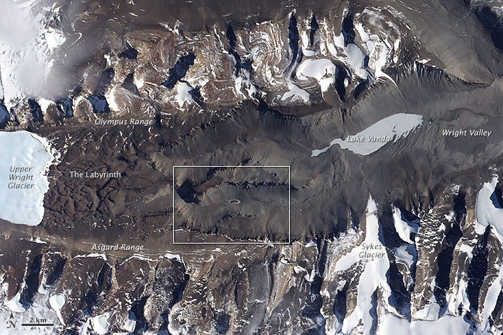
Saltiest Pond on Earth(January 3, 2014)
With a salinity level over 40 percent, Don Juan is significantly saltier than most of the other hypersaline lakes around the world. The Dead Sea has a
salinity of 34 percent; the Great Salt Lake varies between 5 and 27 percent. Earth’s oceans have an average salinity of 3.5 percent.
While hydrologists have long thought that groundwater bubbled up from below to feed the pond, recent research by Brown University geologists Jay Dickson
and James Head has shown that the water most likely comes from the atmosphere. By setting up cameras that took thousands of time-lapse photographs of
the lake, the scientists observed that salts in the soil suck available moisture from the air through a process called deliquescence. These water-rich salts
then trickle down slopes toward the pond, often mixing with small amounts of melt water from snow and ice. The process creates dark water tracks on
the surface, some of which are visible in the ALI image.
https://www.geonames.org/6632253/don-juan-pond.html
Re: Weather history miscellany
https://www.weather.gov/abr/This_Day_in ... ory_Dec_29
1894: A severe freeze hit Florida destroying fruit and causing considerable damage to trees.

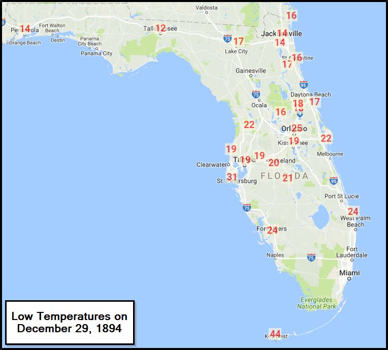
1894: A severe freeze hit Florida destroying fruit and causing considerable damage to trees.


Re: Weather history miscellany
MODIS Image of the day

Cloud Wakes Behind Juan Fernández Islands, Chile(12/25/2024)
As wind blows across a flat surface, such as the ocean, it moves steadily in the direction of the wind. When it slams into a tall, immobile
object (in this case, volcanic peaks), forward motion stops, and the wind is forced around both sides of the object. The uneven motion
creates turbulence in the atmosphere and, when conditions are right, disrupts cloud formation behind the object. The shape of the clouds
on the lee side of islands can take on various shapes, from complex swirling eddies to more simple shapes, such as these cloud wakes.
https://www.geonames.org/8261465/juan-fernandez.html
Re: Weather history miscellany
https://www.weather.gov/abr/This_Day_in ... ory_Dec_30
1960: A massive accumulation of snow, 68.2 inches to be exact, buries the Japanese city of Tsukayama in 24 hours. Tsukayama is located in the coastal mountains inland from the Sea of Japan along Honshu's west coast and subject to significant sea-effect snowfalls. Click HERE for more information from the Papers in Meteorology and Geophysics.

https://www.geonames.org/7553157/tsukayama-eki.html
2014: Steam Devils were seen over Lake Superior near Saginaw, Minnesota. Click HERE for more information from the Minnesota Public Radio.
1960: A massive accumulation of snow, 68.2 inches to be exact, buries the Japanese city of Tsukayama in 24 hours. Tsukayama is located in the coastal mountains inland from the Sea of Japan along Honshu's west coast and subject to significant sea-effect snowfalls. Click HERE for more information from the Papers in Meteorology and Geophysics.

https://www.geonames.org/7553157/tsukayama-eki.html
2014: Steam Devils were seen over Lake Superior near Saginaw, Minnesota. Click HERE for more information from the Minnesota Public Radio.
Re: Weather history miscellany
MODIS Image of the day
Spring Rains Spur Growth in the Pantanal
In this type of false-color image, vegetation appears green, water is inky-blue, open land looks tan or brown, and burn scars range from light tan to dark brown, depending on completeness of burn, temperature of the fire, the soil beneath, and other factors. Very fresh burn scars usually look brick red. Clouds may appear white, and, in some cases, clouds can have a tint of light blue.
https://www.geonames.org/3449174/sao-francisco.html
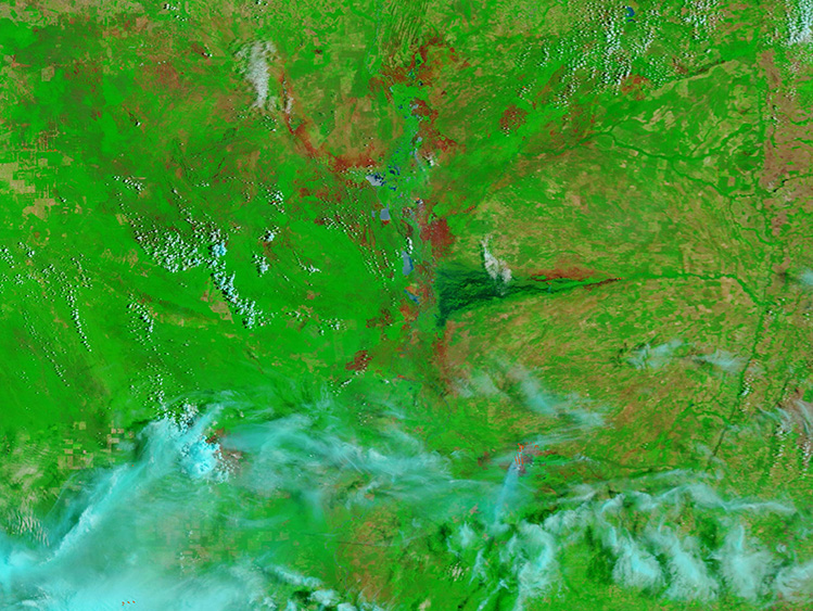
October 31, 2024 |

December 16, 2024 |
Spring Rains Spur Growth in the Pantanal
In this type of false-color image, vegetation appears green, water is inky-blue, open land looks tan or brown, and burn scars range from light tan to dark brown, depending on completeness of burn, temperature of the fire, the soil beneath, and other factors. Very fresh burn scars usually look brick red. Clouds may appear white, and, in some cases, clouds can have a tint of light blue.
https://www.geonames.org/3449174/sao-francisco.html
Re: Weather history miscellany
https://www.weather.gov/abr/This_Day_in ... ory_Dec_31
1876: A heavy snowstorm hit southern Arkansas, with amounts well over 20 inches in places. 28 inches was reported near Warren, and 24–28 inches was reported at Arkansas City.

1882: Downtown San Francisco saw 3.5 inches of snow.
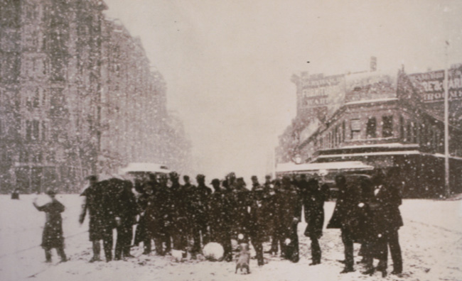
Click HERE for more information from thestormking.com
1890: According to the National Meteorological Library and Archive from the United Kingdom, during December 1890, Westminster, England saw zero hours of sunshine.

1876: A heavy snowstorm hit southern Arkansas, with amounts well over 20 inches in places. 28 inches was reported near Warren, and 24–28 inches was reported at Arkansas City.

1882: Downtown San Francisco saw 3.5 inches of snow.

Click HERE for more information from thestormking.com
1890: According to the National Meteorological Library and Archive from the United Kingdom, during December 1890, Westminster, England saw zero hours of sunshine.

Re: Weather history miscellany
MODIS Image of the day

Ice-up Begins in the Northern Caspian Sea(12/22/2024)
The Caspian Sea isn’t really a sea but in fact a giant lake that spans roughly 1,000 kilometers (600 miles) from north to south. The northern portion of the lake holds only about 1 percent of the Caspian’s volume and is surrounded by Russia, in the northwest, and Kazakhstan. It is very shallow, with an average depth of only 5 to 6 meters (16 to 19 feet) and it receives fresh water from the Volga River, making it the least saline section of the massive Sea. The northerly latitude, low salinity, and shallow depth all contribute to setting the stage for this portion of the lake to freeze over in most winters while the rest of the Caspian remains ice-free.
https://www.geonames.org/630671/caspian-sea.html
Re: Weather history miscellany
https://www.weather.gov/abr/This_Day_in ... ory_Jan_01
1767: The morning temperature in Boston was -8°F!
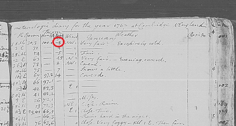
The image above is from a tweet by Brian Brettschneider.
1961: A three-day-long ice storm was beginning over northern Idaho, which produced an accumulation of ice eight inches thick, a U.S. record. Dense fog, which blanketed much of northern Idaho from Grangeville to the Canadian border, deposited the ice on power and phone lines, causing widespread power outages. Click HERE for more information from the website winterstormsofamerica.weebly.com.
1999: The start of 1999 was ushered in with snow, ice, and freezing weather across central and south-central Nebraska. On New Year's Day, a steady snowfall along and north of Interstate 80 dumped from 1 to 5 inches of snow. By late morning, freezing drizzle developed southeast of Hastings and eventually coated area roads with a layer of ice. Light snow later that evening made travel even more treacherous. Several accidents occurred on the Interstates and Highway 30. Once the ice and snow ended, arctic air spilled across the area abroad 20 to 30 mph north winds. Blowing and drifting of the fallen snow caused reduced visibilities for a time on the 2nd. Temperatures dropped to 5 to 15 below zero through midday the 3rd.
1767: The morning temperature in Boston was -8°F!

The image above is from a tweet by Brian Brettschneider.
1961: A three-day-long ice storm was beginning over northern Idaho, which produced an accumulation of ice eight inches thick, a U.S. record. Dense fog, which blanketed much of northern Idaho from Grangeville to the Canadian border, deposited the ice on power and phone lines, causing widespread power outages. Click HERE for more information from the website winterstormsofamerica.weebly.com.
1999: The start of 1999 was ushered in with snow, ice, and freezing weather across central and south-central Nebraska. On New Year's Day, a steady snowfall along and north of Interstate 80 dumped from 1 to 5 inches of snow. By late morning, freezing drizzle developed southeast of Hastings and eventually coated area roads with a layer of ice. Light snow later that evening made travel even more treacherous. Several accidents occurred on the Interstates and Highway 30. Once the ice and snow ended, arctic air spilled across the area abroad 20 to 30 mph north winds. Blowing and drifting of the fallen snow caused reduced visibilities for a time on the 2nd. Temperatures dropped to 5 to 15 below zero through midday the 3rd.
Re: Weather history miscellany
MODIS Image of the day

The Bahamas(12/22/2024)
The iridescent colors are due to shallow depths of the Great Bahama Bank, a massive underwater limestone-rich platform underlying Andros Island in the west, Eleuthera Island in the east, and multiple islands between the two. The waters over the Grand Bahama Bank are extremely shallow, sometimes only about knee-deep. Limestone is a rock that has its basis in fragments of sea creatures, such as corals and foraminifera (single-celled organisms with a calcium rich shell), and this platform has been accumulating since at least the Cretaceous Period.
https://www.geonames.org/3572887/common ... hamas.html
Re: Weather history miscellany
https://www.weather.gov/abr/This_Day_in ... ory_Jan_02
1897: Tornadoes in January? Two tornadoes touched down on this day. The first tornado touched down in Mooringsport, Louisiana, killing five people and injuring 21 others. The second tornado occurred at Benton, Arkansas. Although this tornado was more destructive in regards to property damage, it caused one death.
1949: A blizzard raged and brought heavy snow, strong winds, and cold temperatures to South Dakota, Wyoming, Colorado, and Nebraska.
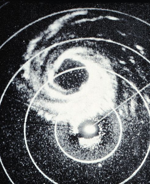
1955: Hurricane Alice passed through the Islands of Saint Martin and Saba in the Caribbean Sea on this day. Alice, which developed on December 30, 1954, is the only known Atlantic hurricane to span two calendar years. The image below is courtesy of the NOAA Photo Library.
1999: A powerful winter storm developed over the Texas panhandle and moved northeast through the Missouri bootheel and then north northeast through eastern Illinois and into Michigan. Snow began accumulating in east-central Illinois and areas south of Chicago during the early evening hours of New Year's Day and overspread the city and north suburbs by midnight. Snow continued through the night and much of the day Saturday, January 2. The heaviest snow fell during the daytime hours Saturday and tapered off by late afternoon or early evening and ended by late evening. Northeast winds were 20 to 30 mph with a few higher gusts during the day Saturday. Winds gusted to over 50 mph along the Lake Michigan shoreline. The strong wind coming off the lake enhanced snowfall totals within about 10 miles of the lake. Snowfall was generally 9 to 15 inches over north central and east central Illinois and in the Chicago suburbs. Snowfall in Chicago and the north suburbs in Lake County was 18 to 22 inches. Winds subsided Saturday evening as the storm center passed over southern Lake Michigan. Then strong northwest winds developed Sunday, causing considerable blowing and drifting and hampering clean-up efforts.
1897: Tornadoes in January? Two tornadoes touched down on this day. The first tornado touched down in Mooringsport, Louisiana, killing five people and injuring 21 others. The second tornado occurred at Benton, Arkansas. Although this tornado was more destructive in regards to property damage, it caused one death.
1949: A blizzard raged and brought heavy snow, strong winds, and cold temperatures to South Dakota, Wyoming, Colorado, and Nebraska.
1955: Hurricane Alice passed through the Islands of Saint Martin and Saba in the Caribbean Sea on this day. Alice, which developed on December 30, 1954, is the only known Atlantic hurricane to span two calendar years. The image below is courtesy of the NOAA Photo Library.

1999: A powerful winter storm developed over the Texas panhandle and moved northeast through the Missouri bootheel and then north northeast through eastern Illinois and into Michigan. Snow began accumulating in east-central Illinois and areas south of Chicago during the early evening hours of New Year's Day and overspread the city and north suburbs by midnight. Snow continued through the night and much of the day Saturday, January 2. The heaviest snow fell during the daytime hours Saturday and tapered off by late afternoon or early evening and ended by late evening. Northeast winds were 20 to 30 mph with a few higher gusts during the day Saturday. Winds gusted to over 50 mph along the Lake Michigan shoreline. The strong wind coming off the lake enhanced snowfall totals within about 10 miles of the lake. Snowfall was generally 9 to 15 inches over north central and east central Illinois and in the Chicago suburbs. Snowfall in Chicago and the north suburbs in Lake County was 18 to 22 inches. Winds subsided Saturday evening as the storm center passed over southern Lake Michigan. Then strong northwest winds developed Sunday, causing considerable blowing and drifting and hampering clean-up efforts.
Re: Weather history miscellany
MODIS Image of the day

Ship Tracks off the Iberian Peninsula(12/25/2024)
Some of the aerosols generated by modern ships are soluble in water and can serve as “cloud seeds” around which cloud droplets can form. Clouds created in way tend to be brighter than the background marine clouds, because clouds infused with ship exhaust tend to have more and smaller droplets than normal marine clouds, which are typically seeded by larger, naturally occurring particles such as salt evaporating from the sea.
Ship tracks typically form in areas where low-lying stratocumulus clouds are present, so the mix of bright lines across a duller background of low-lying cloud seen in this image is a common occurrence where ship travel is heavy.
https://www.geonames.org/3122425/cabo-finisterre.html
Re: Weather history miscellany
https://www.weather.gov/abr/This_Day_in ... ory_Jan_03
1949: During the late afternoon hours, an estimated F4 tornado destroyed Warren, Arkansas.
The tornado killed 55 people and injured more than 250 others. The destruction of the Bradley mill displaced 1,000 employees.
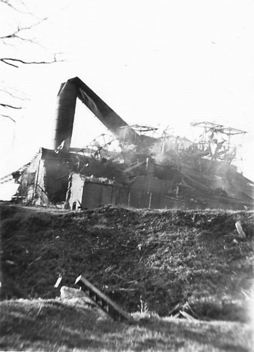
The image above is courtesy of the website, Ancestry.com.
1949: During the late afternoon hours, an estimated F4 tornado destroyed Warren, Arkansas.
The tornado killed 55 people and injured more than 250 others. The destruction of the Bradley mill displaced 1,000 employees.

The image above is courtesy of the website, Ancestry.com.
Re: Weather history miscellany
NASA Earth Observatory - 2011
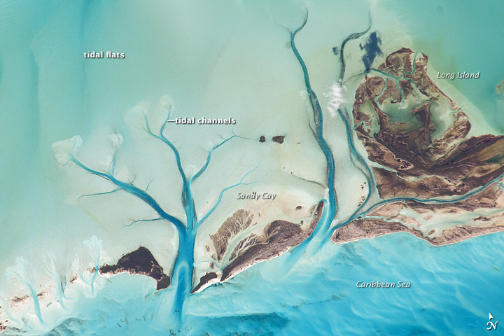
Tidal Flats and Channels, Long Island, Bahamas(November 27, 2010)
The islands of the Bahamas are situated on large depositional platforms—the Great and Little Bahama Banks—composed mainly of carbonate sediments ringed by reefs. The islands are the only parts of the platform currently exposed above sea level. The sediments were formed mostly from the skeletal remains of organisms settling to the sea floor; over geologic time, these sediments consolidated to form carbonate sedimentary rocks such as limestone.
This astronaut photograph provides a view of tidal flats and channels near Sandy Cay, on the western side of Long Island and along the eastern margin of the Great Bahama Bank. The continuously exposed parts of the island are brown, a result of soil formation and vegetation growth. To the north of Sandy Cay, an off-white tidal flat composed of carbonate sediments is visible; light blue-green regions indicate shallow water on the tidal flat. The tidal flow of seawater is concentrated through gaps in the land surface, leading to the formation of relatively deep channels that cut into the sediments. The channels and areas to the south of the island have a vivid blue color that indicates deeper water.
https://www.geonames.org/3572005/long-island.html
Re: Weather history miscellany
https://www.weather.gov/abr/This_Day_in ... ory_Jan_04
1917: A tornado with estimated F3 damage cut a 15-mile path and struck a school at Vireton in Pittsburg
County, Oklahoma, killing 16 people. It ranks as the 4th worst school tornado disaster in U.S. history.
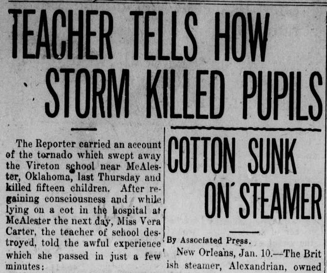
You can read the full article from the Sweetwater Daily Reporter by clicking HERE.
1917: A tornado with estimated F3 damage cut a 15-mile path and struck a school at Vireton in Pittsburg
County, Oklahoma, killing 16 people. It ranks as the 4th worst school tornado disaster in U.S. history.

You can read the full article from the Sweetwater Daily Reporter by clicking HERE.