Weather history miscellany
Re: Weather history miscellany
https://www.weather.gov/abr/This_Day_in ... ory_nov_11
1940: An Armistice Day storm raged across the Great Lakes Region and the Upper Midwest. A blizzard left 49 dead in Minnesota, and gales on Lake Michigan caused shipwrecks resulting in 59 deaths. Up to seventeen inches of snow fell in Iowa, and at Duluth MN, the barometric pressure reached 28.66 inches. The blizzard claimed a total of 154 lives and killed thousands of cattle in Iowa. Huge snowdrifts isolated whole towns. Click HERE for more information, including pictures, from the NWS Office in La Crosse.
1940: An Armistice Day storm raged across the Great Lakes Region and the Upper Midwest. A blizzard left 49 dead in Minnesota, and gales on Lake Michigan caused shipwrecks resulting in 59 deaths. Up to seventeen inches of snow fell in Iowa, and at Duluth MN, the barometric pressure reached 28.66 inches. The blizzard claimed a total of 154 lives and killed thousands of cattle in Iowa. Huge snowdrifts isolated whole towns. Click HERE for more information, including pictures, from the NWS Office in La Crosse.
Re: Weather history miscellany
https://www.weather.gov/abr/This_Day_in ... ory_nov_12
1970: The deadliest tropical cyclone ever recorded, and one of the deadliest natural disasters in modern times occurred on this day in East Pakistan, now Bangladesh. The Bhola Cyclone first formed over the Bay of Bengal on November 8 and traveled north. This cyclone reached peak intensity, Category 3, on the 11, and made landfall on the coast of East Pakistan the following afternoon. The Bhola Cyclone killed an estimated 500,000 people and caused nearly $90 million in damage (1970 USD).
1970: The deadliest tropical cyclone ever recorded, and one of the deadliest natural disasters in modern times occurred on this day in East Pakistan, now Bangladesh. The Bhola Cyclone first formed over the Bay of Bengal on November 8 and traveled north. This cyclone reached peak intensity, Category 3, on the 11, and made landfall on the coast of East Pakistan the following afternoon. The Bhola Cyclone killed an estimated 500,000 people and caused nearly $90 million in damage (1970 USD).
Re: Weather history miscellany
MODIS Image of the day
Burn Scars Come and Go in Australia
https://www.geonames.org/2074837/gulf-o ... taria.html

October 26, 2023 |

November 5, 2024 |
Burn Scars Come and Go in Australia
https://www.geonames.org/2074837/gulf-o ... taria.html
Re: Weather history miscellany
https://www.weather.gov/abr/This_Day_in ... ory_nov_13
1946: General Electric scientists produced snow in the Massachusetts Berkshires in the first modern-day cloud seeding experiment. Scientist Vincent Schaefer dropped six pounds of dry ice pellets into a cloud over Pittsfield, MA. The cloud seeding experiment produced snowfall, as a 4-mile long cloud was converted into snow flurries. The success of the experiment became the basis of many weather modification projects.
1946: General Electric scientists produced snow in the Massachusetts Berkshires in the first modern-day cloud seeding experiment. Scientist Vincent Schaefer dropped six pounds of dry ice pellets into a cloud over Pittsfield, MA. The cloud seeding experiment produced snowfall, as a 4-mile long cloud was converted into snow flurries. The success of the experiment became the basis of many weather modification projects.
Re: Weather history miscellany
https://www.weatherforyou.com/weather_history/11-14
1964 - With the help of a fresh three inch cover of snow, the temperature at Ely, NV, dipped to 15 degrees below zero to establish an all-time record low for the month of November. That record of -15 degrees was later equalled on the 19th of November in 1985. (The Weather Channel)
1974 - A storm produced 15 inches of snow at the Buffalo, NY, airport, and 30 inches on the south shore of Lake Erie. (David Ludlum)
1986 - An early season cold wave set more than 200 records from the northwestern U.S. to the east coast over a seven day period. For some places it proved to be the coldest weather of the winter season. (Sandra and TI Richard Sanders - 1987)
1988 - A massive storm produced snow and gusty winds in the western U.S., with heavy snow in some of the higher elevations. Winds gusted to 66 mph at Show Low AZ, and Donner Summit, located in the Sierra Nevada Range of California, was buried under 23 inches of snow. Heavy rain soaked parts of California, with 3.19 inches reported at Blue Canyon. (The National Weather Summary) (Storm Data)
Re: Weather history miscellany
https://www.weather.gov/abr/This_Day_in ... ory_nov_15
1996: An intense, lake effect snow event came to an end over western New York, northeastern Ohio, and northwest Pennsylvania. Chardon, Ohio was buried under 68.9 of snow over a six-day period. Edinboro, Pennsylvania checked in with 54.8 inches. 18.5 inches blanketed Cleveland, Ohio and 42 inches fell at Sherman, New York.
https://www.geonames.org/7165362/city-of-chardon.html
https://www.geonames.org/5188311/boroug ... nboro.html
https://www.geonames.org/5150529/cleveland.html
https://www.geonames.org/5137954/town-of-sherman.html
Re: Weather history miscellany
https://www.weatherforyou.com/weather_history/11-16
1958 - More than six inches of snow fell at Tucson, AZ. (David Ludlum) (The Weather Channel)
1988 - A powerful low pressure system in the north central U.S. produced high winds across the Great Lakes Region, with wind gusts to 60 mph reported at Chicago IL. Heavy snow blanketed much of Minnesota, with eleven inches reported at International Falls. (The National Weather Summary) (Storm Data)
2006 - An F-3 tornado strikes Riegelwood, NC causing eight deaths and twenty injuries
Re: Weather history miscellany
https://www.weatherforyou.com/weather_history/11-17
1988 - Another in a series of storms brought heavy snow to the mountains of the western U.S. Totals ranged up to 17 inches at Bob Scott Summit in Nevada. Winds around Reno NV gusted to 80 mph. The Alta and Sundance ski resorts in Utah received 14 inches of snow. (The National Weather Summary) (Storm Data)
1988 - Another in a series of storms brought heavy snow to the mountains of the western U.S. Totals ranged up to 17 inches at Bob Scott Summit in Nevada. Winds around Reno NV gusted to 80 mph. The Alta and Sundance ski resorts in Utah received 14 inches of snow. (The National Weather Summary) (Storm Data)
Re: Weather history miscellany
NASA Earth Observatory - 2012
Fog in Argentina’s Lake District
https://www.geonames.org/3844455/lago-meliquina.html
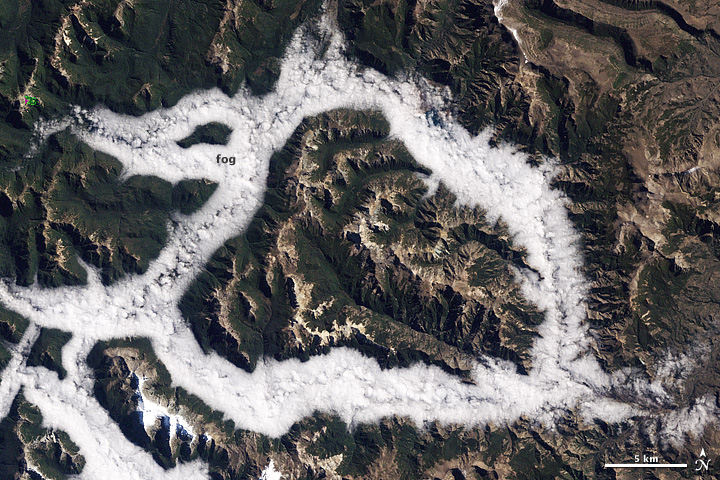
March 29, 1987 |
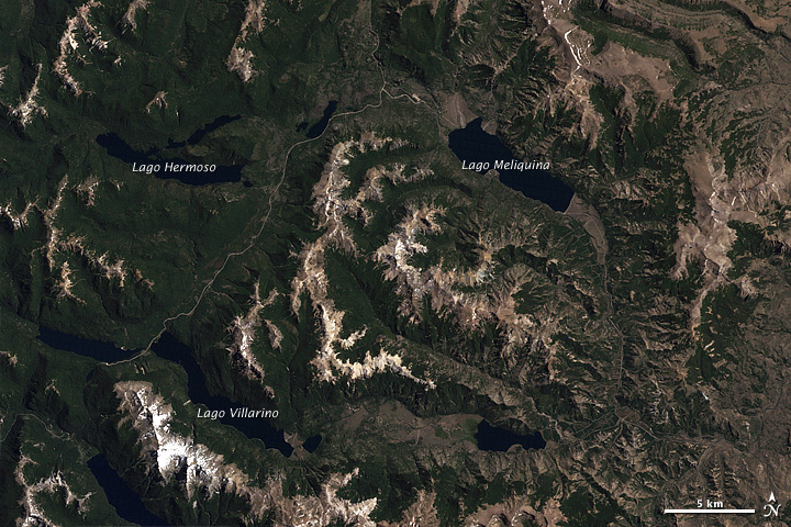
February 15, 2001 |
Fog in Argentina’s Lake District
https://www.geonames.org/3844455/lago-meliquina.html
Re: Weather history miscellany
https://www.weatherforyou.com/weather_history/11-18
1986 - The first of two successive snowstorms struck the northeastern U.S. The storm produced up to 20 inches of snow in southern New Hampshire. Two days later a second storm produced up to 30 inches of snow in northern Maine. (Storm Data)
1988 - Thunderstorms developing along a warm front drenched Little Rock AR with 7.01 inches of rain, smashing their previous record for the date of 1.91 inches. (The National Weather Summary)
Re: Weather history miscellany
NASA Earth Observatory
Signs of Sea Level Rise in the Bahamas
“One of the lessons from what’s happened on Andros is that the effects of sea level rise are not uniform or intuitive,” said Purkis, noting that the shorelines saw little change because they were adequately replenished with sediment. “As sea level continues to rise,” he said, “people should understand that shorelines might stay in place in some areas, while inland marshes might expand and hollow out islands from the inside.”
https://www.geonames.org/3571446/point-simon.html
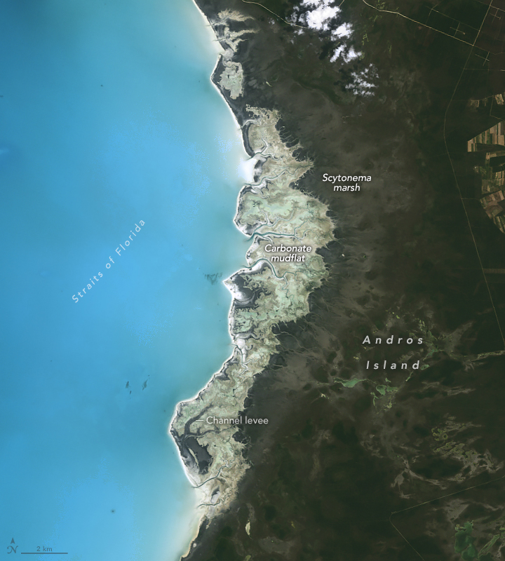 April 29, 1986 |
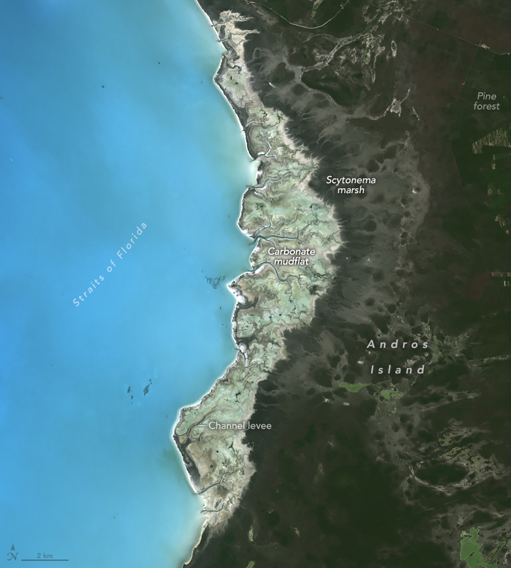 May 15, 2024 |
“One of the lessons from what’s happened on Andros is that the effects of sea level rise are not uniform or intuitive,” said Purkis, noting that the shorelines saw little change because they were adequately replenished with sediment. “As sea level continues to rise,” he said, “people should understand that shorelines might stay in place in some areas, while inland marshes might expand and hollow out islands from the inside.”
https://www.geonames.org/3571446/point-simon.html
Re: Weather history miscellany
https://www.weather.gov/abr/This_Day_in ... ory_nov_19
1930: A rare, estimated F4 tornado struck the town of Bethany, Oklahoma. Between 9:30 am and 9:58 am CST, it moved north-northeast from 3 miles west of the Oklahoma City limits, and hit the eastern part of Bethany. About 110 homes and 700 other buildings, or about a fourth of the town, were damaged or destroyed. Near the end of the damage path, 3.5 miles northeast of Wiley Post Airfield, the tornado hit the Camel Creek School. Buildings blew apart just as the students were falling to the floor and looking for shelter, and five students and a teacher were killed. A total of 23 people were killed and another 150 injured, with 77 being seriously injured. Damage estimates were listed at $500,000.
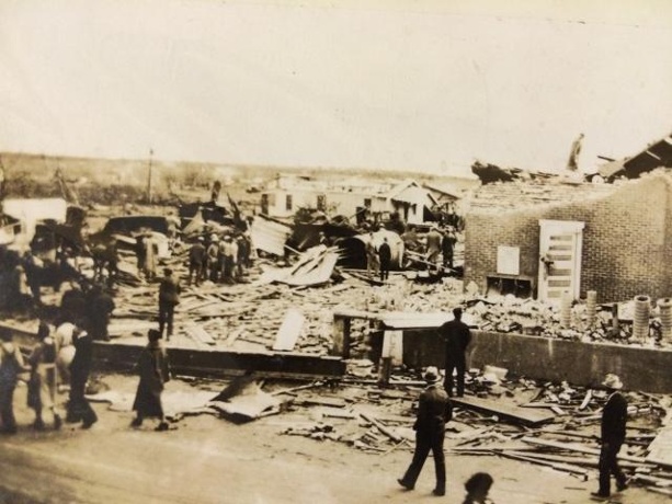
Tornado damage in Bethany, Oklahoma. Image courtesy of KOCO
in Oklahoma City. Click HERE for more pictures from KOCO.com
1930: A rare, estimated F4 tornado struck the town of Bethany, Oklahoma. Between 9:30 am and 9:58 am CST, it moved north-northeast from 3 miles west of the Oklahoma City limits, and hit the eastern part of Bethany. About 110 homes and 700 other buildings, or about a fourth of the town, were damaged or destroyed. Near the end of the damage path, 3.5 miles northeast of Wiley Post Airfield, the tornado hit the Camel Creek School. Buildings blew apart just as the students were falling to the floor and looking for shelter, and five students and a teacher were killed. A total of 23 people were killed and another 150 injured, with 77 being seriously injured. Damage estimates were listed at $500,000.

Tornado damage in Bethany, Oklahoma. Image courtesy of KOCO
in Oklahoma City. Click HERE for more pictures from KOCO.com
Re: Weather history miscellany
https://www.weatherforyou.com/weather_history/11-20
1900 - An unusual tornado outbreak in the Lower Mississippi Valley resulted in 73 deaths and extensive damage across Arkansas, Mississippi and Tennessee. (David Ludlum)
1914 - The high temperature of 28 degrees at Atlanta, GA, was their earliest daily high below the freezing mark. (The Weather Channel)
1988 - Thunderstorms developing ahead of a fast moving cold front produced severe weather in the Upper Ohio Valley and the Middle Atlantic Coast Region during the afternoon and early evening. Thunderstorm winds gusted to 69 mph at Kennedy Airport in New York City, and winds along the cold front itself gusted to 56 mph at Cincinnati OH. The same storm produced snow in Kansas, Missouri and Illinois, with eight inches reported at Rolla MO. (The National Weather Summary) (Storm Data)
Re: Weather history miscellany
NASA Earth Observatory - November Puzzler

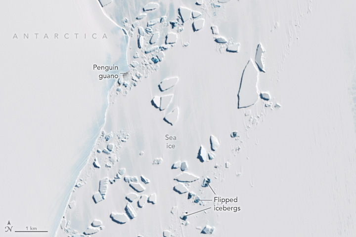
Every month on Earth Matters, we offer a puzzling satellite image. The November 2024 puzzler is shown above. Your
challenge is to use the comments section to tell us where it is, what we are looking at, and why it is interesting.
Reply here.

Every month on Earth Matters, we offer a puzzling satellite image. The November 2024 puzzler is shown above. Your
challenge is to use the comments section to tell us where it is, what we are looking at, and why it is interesting.
Reply here.
