Weather history miscellany
Re: Weather history miscellany
https://www.weather.gov/abr/This_Day_in ... ory_Aug_09
1878: The second deadliest tornado in New England history struck Wallingford, Connecticut, killing 34 persons, injuring 100 others, and destroying thirty homes. The tornado started as a waterspout over a dam on the Quinnipiac River. It was 400 to 600 feet wide and had a short path length of two miles. The deadliest New England tornado occurred in 1953 when an F4 killed 90 people in Worcester, Massachusetts.
https://newenglandhistoricalsociety.com ... ting-town/
Re: Weather history miscellany
https://www.weather.gov/abr/This_Day_in ... ory_Aug_10
1856: A hurricane destroyed Isle Dernieres or Last Island, a pleasure resort south-southwest of New Orleans on this day. The highest points of the island were under five feet of water. The resort hotel was destroyed, along with the island's gambling establishments. Over 200 people perished, and the island lost all its vegetation and split in half. Only one cow remained on the island after the catastrophe. The Last Island is now just a haven for pelicans and other seabirds. The steamer Nautilus foundered during the storm. The lone survivor clung to a bale of cotton and washed ashore sometime later.
https://www.geonames.org/4322011/isles-dernieres.html
Re: Weather history miscellany
https://www.weather.gov/abr/This_Day_in ... ory_Aug_11
1940: A Category 2 hurricane struck the Georgia and South Carolina coast. A 13-foot storm tide was measured along the South Carolina coast, while over 15 inches of rain fell across northern North Carolina. Significant flooding and landslides struck Georgia, North Carolina, Tennessee, and Virginia during the system's slow trek as a weakening tropical storm, and then as an extratropical cyclone, through the Southeast. The landslides which struck North Carolina were considered a once in a century event. Damages relating to the storm totaled $13 million (1940 USD), and 50 people perished.
1940: A Category 2 hurricane struck the Georgia and South Carolina coast. A 13-foot storm tide was measured along the South Carolina coast, while over 15 inches of rain fell across northern North Carolina. Significant flooding and landslides struck Georgia, North Carolina, Tennessee, and Virginia during the system's slow trek as a weakening tropical storm, and then as an extratropical cyclone, through the Southeast. The landslides which struck North Carolina were considered a once in a century event. Damages relating to the storm totaled $13 million (1940 USD), and 50 people perished.
Re: Weather history miscellany
https://www.weather.gov/abr/This_Day_in ... ory_Aug_12
1752: The following is from the Journals of the Rev. Thomas Smith, and the Rev. Samuel Deane, published in 1849. “In the evening there was dismal thunder and lightning, and abundance of rain, and such a hurricane as was never the like in these parts of the world.” This hurricane struck Portland, Maine. Click HERE to read their Journals.
2004: Hurricane Charley was the third named storm and the second hurricane of the 2004 Atlantic hurricane season. Charley lasted from August 9 to August 15, and at its peak intensity, it attained 150 mph winds, making it a strong Category 4 hurricane on the Saffir-Simpson Hurricane Scale. It made landfall in southwestern Florida at maximum strength, making it the most powerful hurricane to hit the United States since Hurricane Andrew struck Florida in 1992.
Re: Weather history miscellany
MODIS Image of the day
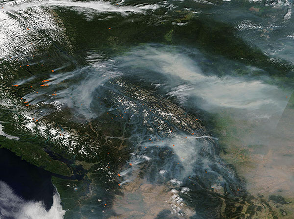
Extreme Heat Fuels Extreme Fire Season( 8/8/2024)
True-color image focused on fires blazing in British Columbia. Fires are also visible in the state of Washington.
https://www.geonames.org/12031873/vancouver.html

Extreme Heat Fuels Extreme Fire Season( 8/8/2024)
True-color image focused on fires blazing in British Columbia. Fires are also visible in the state of Washington.
https://www.geonames.org/12031873/vancouver.html
Re: Weather history miscellany
https://www.weatherforyou.com/weather_history/8-13
1980 - The afternoon high at New York City was just 89 degrees. But there were fifteen days of 90 degree heat during the month, their hottest August of record. (The Weather Channel)
1988 - A dozen cities in the northeastern U.S. reported record high temperatures for the date. Lansing MI reported a record 35 days of 90 degree weather for the year, Detroit MI reported a record 37 days of 90 degree heat for the year, and Williamsport PA reported a record 38 days of 90 degree weather for the year. (The National Weather Summary)
2014 - An official, New York State 24 hour precipitation record was set at Islip, NY on August 12-13 when 13.57" of rain fell.
Re: Weather history miscellany
https://www.weatherforyou.com/weather_history/8-14
1898 - A deadly, estimated F4 tornado moved southeast from 12 miles northwest of Clear Lake, South Dakota, passing 7 miles north of town and ending about 4 miles west of Gary. Deaths occurred on two farms. One man was killed when the kitchen of his farm house was torn off. Five members of one family were killed along with two labors on another farm as every building was swept away. Buildings suffered massive damage on eight farms. This tornado was one of the earliest, estimated F4 tornadoes on record for South Dakota.
1936 - Temperatures across much of eastern Kansas soared above 110 degrees. Kansas City MO hit an all-time record high of 113 degrees. It was one of sixteen consecutive days of 100 degree heat for Kansas City. During that summer there were a record 53 days of 100 degree heat, and during the three summer months Kansas City received just 1.12 inches of rain. (The Kansas City Weather Almanac)
1988 - Eighteen cities in the northeastern U.S. reported record high temperatures for the date, and the water temperature at Lake Erie reached a record 80 degrees. Portland ME reported a record fourteen straight days of 80 degree weather. Milwaukee WI reported a record 34 days of 90 degree heat for the year. Afternoon and evening thunderstorms resulted in about fifty reports of severe weather in the northeastern U.S. One person was killed at Stockbridge MI when a tornado knocked a tree onto their camper. (The National Weather Summary) (Storm Data)
Re: Weather history miscellany
NASA Earth Observatory

Northwest Territories Ablaze(August 10, 2024)
Boreal forests in this northerly Canadian territory have evolved to burn,
but the increasing frequency of fires is putting ecosystems to the test.

Northwest Territories Ablaze(August 10, 2024)
Boreal forests in this northerly Canadian territory have evolved to burn,
but the increasing frequency of fires is putting ecosystems to the test.
Re: Weather history miscellany
https://www.weatherforyou.com/weather_history/8-15
1946 - Saint Louis, MO, was deluged with a record 8.78 inches of rain in 24 hours. (The Weather Channel)
1988 - Thirty five cities in twenty states in the north central and northeastern U.S. reported record high temperatures for the date, including Lamoni IA and Baltimore MD, where the mercury hit 105 degrees. Temperatures 100 degrees or above were reported in twenty-two states. Pierre SD was the hot spot in the nation with a high of 114 degrees. Bluefield WV reported eight straight days of record heat. (The National Weather Summary)
Re: Weather history miscellany
NASA Earth Observatory
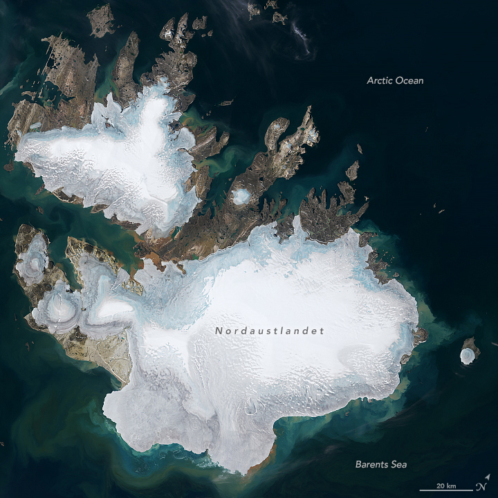
Svalbard Melts(August 9, 2024)
Svalbard is one of the fastest-warming places on the planet.
https://www.geonames.org/607197/nordaustlandet.html

Svalbard Melts(August 9, 2024)
Svalbard is one of the fastest-warming places on the planet.
https://www.geonames.org/607197/nordaustlandet.html
Re: Weather history miscellany
https://www.weather.gov/abr/This_Day_in ... ory_Aug_16
1992: One of the most destructive United States hurricanes of record started modestly as a tropical wave that emerged from the west coast of Africa on August 14. The wave spawned a tropical depression on August 16, which became Tropical Storm Andrew the next day. Click HERE for more information from the National Hurricane Center.
1992: One of the most destructive United States hurricanes of record started modestly as a tropical wave that emerged from the west coast of Africa on August 14. The wave spawned a tropical depression on August 16, which became Tropical Storm Andrew the next day. Click HERE for more information from the National Hurricane Center.
Re: Weather history miscellany
https://www.weather.gov/abr/This_Day_in ... ory_Aug_17
1946: An estimated F-4 tornado killed 11 people and injured 100 others in the Mankato, Minnesota area around 6:52 PM. The deaths and most of the injuries occurred in the complete destruction of the 26 cabins at the Green Gables tourist camp, 3 miles southwest of Mankato. A 27-ton road grader was reportedly hurled about 100 feet. Another tornado an hour later destroys downtown Wells, Minnesota.
1946: An estimated F-4 tornado killed 11 people and injured 100 others in the Mankato, Minnesota area around 6:52 PM. The deaths and most of the injuries occurred in the complete destruction of the 26 cabins at the Green Gables tourist camp, 3 miles southwest of Mankato. A 27-ton road grader was reportedly hurled about 100 feet. Another tornado an hour later destroys downtown Wells, Minnesota.
- pommystuart
- Posts: 1807
- Joined: Mon May 18, 2020 12:48 am
- Location: Cooranbong, NSW, Australia.
Re: Weather history miscellany
Messy to say the least.
