
No worries, always glad to help
Alaskan Place Names -- Discussion
Moderator: Matteo
Re: Alaskan Place Names -- Discussion
No worries, always glad to help
-
studentforever
- Posts: 781
- Joined: Sun Jul 05, 2020 9:23 am
Re: Alaskan Place Names -- Discussion
I'm nearing the end of Pioneer's transcription and have started the tedious process of checking the transcription file. I've come across a reference to her anchored off triangulation "Knoll" in Pavlof Bay. This would give a more precise location than the current one which just refers to the fairly large Pavlof Bay. So, can I once again beg your expertise to come up with a more precise location.
https://catalog.archives.gov/id/247055104?objectPage=24
Thanks
I'm afraid that I could also benefit from the location of triangulation "Grav" which is on the East side of Pavlof Bay
https://catalog.archives.gov/id/247055104?objectPage=22
They reference several others in the general vicinity so you may (or may not) wish to add them to the database while you have the data to hand.
Thanks again
Last edited by studentforever on Mon Feb 26, 2024 2:43 pm, edited 1 time in total.
Re: Alaskan Place Names -- Discussion
Absolutely!
Its on the eastern side of the promontory where Pavlof Bay is more narrow, shortly north of Cape Tolstoi and 2 Pinnacle Rocks:

I've added it to geonames (position 55.38416, -161.51508) and to our db. Thanks!
Its on the eastern side of the promontory where Pavlof Bay is more narrow, shortly north of Cape Tolstoi and 2 Pinnacle Rocks:
I've added it to geonames (position 55.38416, -161.51508) and to our db. Thanks!
-
studentforever
- Posts: 781
- Joined: Sun Jul 05, 2020 9:23 am
Re: Alaskan Place Names -- Discussion
Thanks, while you were putting in your solution I had found some other problems later in the log and added to the request. At least you now know where to look! When I was starting work on this log I left the triangulation points for later consideration but realised their significance as work progressed. I'm afraid that other requests may come up as I check through the log before I send it off to Caro. I'll try to keep them to points which contribute to Pioneer's activities rather than just the activities of different officers.
Re: Alaskan Place Names -- Discussion
Hey no worries!
They're not so hard to locate, and up to now i think just one was missing from the modern (1955, 1963, 1983 and 1988) maps of topoview (https://ngmdb.usgs.gov/topoview/viewer/), glad to pinpoint all the stations Pioneer encountered and you want to locate!
Grav is shortly north of Knoll, it's a little faint but it's present on the screenshot i put in my previous post, just under upper border. The triangle is visible, the text maybe is too blurry.
I've added it to geonames (position 55.42603, -161.48328) and of course to our db
-
studentforever
- Posts: 781
- Joined: Sun Jul 05, 2020 9:23 am
Re: Alaskan Place Names -- Discussion
Thanks. Pioneer has anchored off triangulation "Tag" at head of Morzhovoi Bay
https://catalog.archives.gov/id/247055104?objectPage=11
Once again her location was the Bay rather than the site so the triangulation would improve things.
https://catalog.archives.gov/id/247055104?objectPage=11
Once again her location was the Bay rather than the site so the triangulation would improve things.
Re: Alaskan Place Names -- Discussion
I think i have to give up on this one... no map I've been able to find report "Tag" (also looked for Jag, Jay, Tay), the only station with a close name is Turn, which is indeed at the head of bay. Looking at the maps there was also a sand promontory at the mouth of the lagoon which does not exist anymore... my guess is either the station has been renamed Turn at some point, or it was on that sand spit and has been washed away since a long time. They usually placed stations on high ground to avoid these kind of things, so i think the station on the spit is a little less probable.
I've found an awesome source for triangulation stations, i'm posting it here.... even if the map is too large to be useful (to locate them properly we still need usgs maps), it's a great checking sheet for station names. It's fairly recent (1985), and in pdf format, which is just awful for maps: https://thesurveystation.com/NGS/Geodet ... Alaska.pdf
Grass, Green and Turn, circled in red, left to right
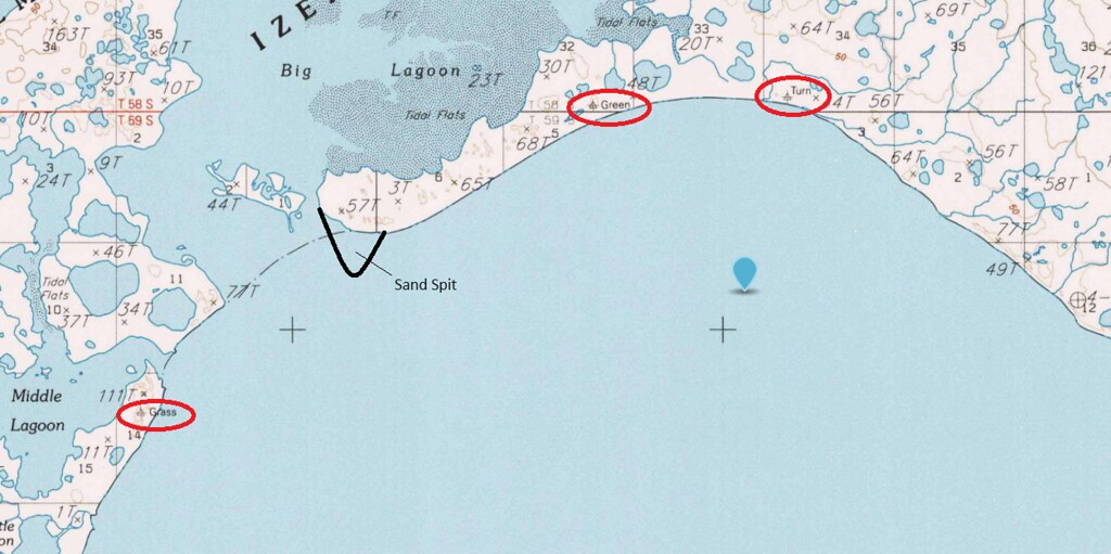
I've added Turn to geonames (position 55.10822, -163.07164) and to our db, as it's possibly our best guess for that station.
I've found an awesome source for triangulation stations, i'm posting it here.... even if the map is too large to be useful (to locate them properly we still need usgs maps), it's a great checking sheet for station names. It's fairly recent (1985), and in pdf format, which is just awful for maps: https://thesurveystation.com/NGS/Geodet ... Alaska.pdf
Grass, Green and Turn, circled in red, left to right
I've added Turn to geonames (position 55.10822, -163.07164) and to our db, as it's possibly our best guess for that station.
-
studentforever
- Posts: 781
- Joined: Sun Jul 05, 2020 9:23 am
Re: Alaskan Place Names -- Discussion
Thanks, I agree about the map, virtually unreadable on my computer.
Pioneer has now referenced Cape Wedge, it's on geo names but I don't think it's on the database.
https://www.geonames.org/5877700/cape-wedge.html
Pioneer has now referenced Cape Wedge, it's on geo names but I don't think it's on the database.
https://www.geonames.org/5877700/cape-wedge.html
Re: Alaskan Place Names -- Discussion
We have both the cape and the light on db, maybe i've not updated the reference thread yet, i think the point or the light (or both) came out quite recently. Will do soon... thread was last updated 26 January, its not that much, but it's indeed been a while and we have added several places to it in the meantime.
-
studentforever
- Posts: 781
- Joined: Sun Jul 05, 2020 9:23 am
Re: Alaskan Place Names -- Discussion
Trying to sort out problems in Pioneer's transcription and was trying to locate Wooden Island Light. A somewhat confusing entry in the pilot guide may assist you to locate it (probably labelled Cape Ommaney Light!). The entry in the pilot guide refers to a clutch of other lights some of which don't seem to appear in geonames or the db either.
https://nauticalcharts.noaa.gov/publica ... 10_WEB.pdf
The entry appears at the bottom of the left hand and top of the right hand columns on page 272. Good luck tracing accurate positions of that little clutch of lights/beacons!!
https://nauticalcharts.noaa.gov/publica ... 10_WEB.pdf
The entry appears at the bottom of the left hand and top of the right hand columns on page 272. Good luck tracing accurate positions of that little clutch of lights/beacons!!
Re: Alaskan Place Names -- Discussion
Google maps imagery is very indistinct in the area, but fortunately bing maps has good closeups. The light is active (the pdf is from 2024) and present on fishing app nautical chart.
I've added Cape Ommaney Light, with Wooden Island Light as an alternate name, both to geonames (position 56.16027, -134.66071) and our database.
I've also added the other lights marking the entrance of Chatham Strait (Helm Point Light and Point Crowley Light - we had just the points) both to geonames and the database. We already had Cape Decision Light
-
studentforever
- Posts: 781
- Joined: Sun Jul 05, 2020 9:23 am
Re: Alaskan Place Names -- Discussion
Thanks. I'm not sure you'll be relieved but my next ship is on the East Coast!!
Re: Alaskan Place Names -- Discussion
It will be interesting dont worry!
Also i think the east coast is a little less covered in the database, so more chances for adding new places to it!
-
studentforever
- Posts: 781
- Joined: Sun Jul 05, 2020 9:23 am
Re: Alaskan Place Names -- Discussion
Back to Pioneer. She references a Course Point which I have tracked down via Mapcarta
https://mapcarta.com/24065602
This entry includes a geonames number which I'm not sure how to use as a search term. I'm sure you do!!
https://mapcarta.com/24065602
This entry includes a geonames number which I'm not sure how to use as a search term. I'm sure you do!!

Re: Alaskan Place Names -- Discussion
The full URL looks like this:
URL: http:/www.geonames.org/5859962/Course Point.html
You can also just use the GeoNames ID:
URL: http:/www.geonames.org/5859962/*.html
URL: http:/www.geonames.org/5859962/Course Point.html
You can also just use the GeoNames ID:
URL: http:/www.geonames.org/5859962/*.html
-
studentforever
- Posts: 781
- Joined: Sun Jul 05, 2020 9:23 am
Re: Alaskan Place Names -- Discussion
Great, I've changed the link on my transcription. But, Matteo, yet another Pioneer reference for the database.
Thanks.
Thanks.
-
studentforever
- Posts: 781
- Joined: Sun Jul 05, 2020 9:23 am
Re: Alaskan Place Names -- Discussion
Pioneer reports a lighthouse on Black Rock (no 1 on the database), verified in this link.
https://www.ibiblio.org/lighthouse/ak.htm
https://www.ibiblio.org/lighthouse/ak.htm
-
studentforever
- Posts: 781
- Joined: Sun Jul 05, 2020 9:23 am
Re: Alaskan Place Names -- Discussion
Pioneer also gives bearings on Rocky Reef, I think this may be Rocky Reef Point which is an Alternate Name for Laida Rocks on Geonames but not in the database.
https://www.geonames.org/5867059/laida-rocks.html
https://www.geonames.org/5867059/laida-rocks.html
Re: Alaskan Place Names -- Discussion
I've added everything to db. Thanks Ros!
I think the Rocky Reef Point alternate name on Laida Rocks is not correct... i'm trying to find out if those rocks were named Rocky Reef, but the point itself should be to the southeast looking at this 1910 map. On that map the rocks have not a name, the point has disappeared in 1940s and later maps.
There are apparently no reefs nearby... will dig deeper, I've added just the point in the meantime.

Re: Alaskan Place Names -- Discussion
Ossabaw Sound, Georgia
spelled Ossibaw Sound in Tuscarora's log
https://www.geonames.org/4214417/ossabaw-sound.html
spelled Ossibaw Sound in Tuscarora's log
https://www.geonames.org/4214417/ossabaw-sound.html