Transcriber Weather


Re: Transcriber Weather
Some of Santa's reindeer were a little hungry, not much grass at the North Pole. These Roosevelt Elk came onto my sister's property during the recent snowfall. She lives 50 km north of Victoria. We had 3 cm of now which was gone in a few hours, she got more and it lasted a couple of days. You don't often see these elk. I think this is just the second time they've come down onto her property.


Re: Transcriber Weather
The Elk are majestic and the pictures of flooding in NSW is surreal. To see the posts one right after the other is an odd sense, humbling. Thank you both.
Re: Transcriber Weather
The first wave of the Atmospheric River showed up and our unofficial rain gauge measured 1.25 inches (just over 3 cm). I understand there was more northerly in the mountains (in snow.) Look out East Coast USA!
Re: Transcriber Weather
Here's the weather forecast for Victoria. The normal values for this time is a Max of 8, a Min of 3 and 55 mm of rain.
| Date | Night | Morning | Afternoon | Evening | Max | Min | Prcp | Wind |
| Monday 12 Dec. | Sunny | Sunny | Fair | 6 | 1 | 0 | 11 | |
| Tuesday 13 Dec. | Partly cloudy | Cloudy | Cloudy | Cloudy | 5 | 0 | 0 | 7 |
| Wednesday 14 Dec. | Partly cloudy | Mainly Sunny | Mainly Sunny | Partly cloudy | 5 | 1 | 0 | 11 |
| Thursday 15 Dec. | Partly cloudy | Mainly Sunny | Mainly Sunny | Clear | 7 | 1 | 0 | 14 |
| Friday 16 Dec. | Clear | Mainly Sunny | Sunny | Clear | 6 | 1 | 0 | 14 |
| Saturday 17 Dec. | Clear | Mainly Sunny | Mainly Sunny | Partly cloudy | 4 | -2 | 0 | 32 |
| Sunday 18 Dec. | Clear | Sunny | Sunny | Clear | -3 | -5 | 0 | 43 |
| Monday 19 Dec. | Clear | Cloudy | Cloudy | Cloudy | -1 | -5 | 0 | 29 |
| Tuesday 20 Dec. | Cloudy | Cloudy | Cloudy | Cloudy | 0 | -2 | 0 | 18 |
| Extremes | 7 | -5 | 0 | 43 | ||||
-
pommystuart

- Posts: 1811
- Joined: Mon May 18, 2020 12:48 am
- Location: Cooranbong, NSW, Australia.
Re: Transcriber Weather
Indeed.

Re: Transcriber Weather
The BC and Washington forecasters seem to disagree in their forecasts for this coming weekend. They are saying no precipitation for Victoria, but rain or snow for Seattle on this side of Puget Sound.
This Afternoon: Partly sunny, with a high near 41. Calm wind.
Tonight: Mostly cloudy, with a low around 32. Light east northeast wind.
Wednesday: Mostly sunny, with a high near 42. North wind 3 to 6 mph.
Wednesday Night: Partly cloudy, with a low around 28. North northeast wind around 6 mph.
Thursday: Mostly sunny, with a high near 43. North northeast wind 6 to 8 mph.
Thursday Night: Mostly clear, with a low around 28.
Friday: Mostly sunny, with a high near 43.
Friday Night: A slight chance of rain and snow after 4am. Partly cloudy, with a low around 29.
Saturday: A chance of rain and snow before 1pm, then a chance of rain. Partly sunny, with a high near 41.
Saturday Night: A chance of rain and snow before 4am, then a chance of snow. Mostly cloudy, with a low around 29.
Sunday: A chance of rain and snow. Mostly cloudy, with a high near 36.
Sunday Night: A chance of snow. Mostly cloudy, with a low around 24.
Monday: A chance of snow. Mostly cloudy, with a high near 34.
Re: Transcriber Weather
-7C this morning and ice on the inside of one window! It's double-glazed but in a north facing room and I didn't have the heating on in there yesterday.
We're having a cold snap in the UK at the moment. Here it's mostly been going down to about -4C and up to about 1C in the sunny weather. Except last weekend when it clouded over and the air temp was above freezing for a couple of days but, as the ground was still frozen, the rain and sleet made the roads and pavements 'interesting'.
It's due to start warming up from tomorrow to more normal temps (min about 2C, max about 8C), except Monday when a max of 13C is forecast (which wouldn't be that bad for a summer day!).
-
pommystuart
- Posts: 1811
- Joined: Mon May 18, 2020 12:48 am
- Location: Cooranbong, NSW, Australia.
Re: Transcriber Weather
FYI. A look at Australia's' possible future.
https://cosmosmagazine.com/earth/austra ... -scenarios
Opps.

https://cosmosmagazine.com/earth/austra ... -scenarios
Opps.
-
pommystuart
- Posts: 1811
- Joined: Mon May 18, 2020 12:48 am
- Location: Cooranbong, NSW, Australia.
Re: Transcriber Weather
Predictions for Christmas Day weather down under.
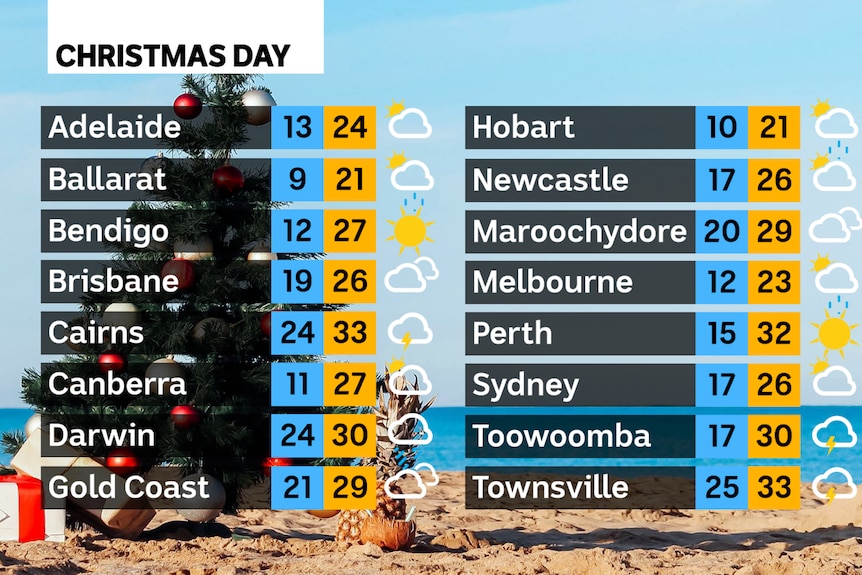
Temps are in °C (of course)
Temps are in °C (of course)

Re: Transcriber Weather
Perth looks good to me. 
It's -6 down here in the balmy south of the UK, but as Janet says, warmer, rainy weather is approaching at last.
It's -6 down here in the balmy south of the UK, but as Janet says, warmer, rainy weather is approaching at last.
-
pommystuart
- Posts: 1811
- Joined: Mon May 18, 2020 12:48 am
- Location: Cooranbong, NSW, Australia.
Re: Transcriber Weather
Save some good weather for me in May and June 2003 please.
Re: Transcriber Weather
Rain. Lots. But 6C!
Re: Transcriber Weather
A few flakes of snow every so often here, but they melt when they hit the ground. 1.7C.